Pages

Wednesday 16 February 2011

A Walk in the Rain - 2 Wainwrights from Newlands

Newlands Hause
The long days of summer when the trail stretches away ahead until the golden evening dresses the hills in patterns of light and shade and the westering sun lights the path homewards are the truly memorable ones. They shine like a beacon in our minds through the dark of winter and bring us back to the hills time and time again as if we are searching for some half remembered place in a dream.

Today at Newlands Hause though was not one of them. Driven before a westerly gale, the rain drifted in watery veils across the open fellsides and a grey nimbostratus hid the higher summits from view. This is perhaps the more usual scene to greet those who come to walk in the Lake District but at least the Ard Cragsfells looked dramatic and Moss Force just above the pass was at its best. But yes - these are excuses - the weather was grim and if I did the walk I would get wet.

Part of the joy of doing the Wainwrights - the fells classified by the late AW Wainwright in his guides to Lakeland - is that some of them can be ascended so quickly and easily that on days like this the getting wet part is not for long enough to become too tiresome. Indeed Latrigg took me and Josh rather less than 10 minutes from the Skiddaw car park and the view from there far outweighs that tiny effort. These two fells I was climbing today - Ard Crags and Knott Rigg - involved slightly under 4 miles of walking and just 1050 feet of ascent for the return trip.

From the small parking area at the top of Newlands Hause set off along the path on the opposite side of the road to the spectacular waterfall of Moss Force - after visiting it 5 minutes the other way - which is actually signposted to Ard Crags if the sign has not since blown away. The path follows the obvious line up a fairly steep grassy ridge ahead past a small rocky outcrop where there was some shelter if only because the wind was blowing the rain over the top of it. After here the steepness eased and the ridge led up past another outcrop to the small cairn atop the grassy ridge of Knott Rigg.

Leaving Knott Rigg the way descends only slightly to cross a wide grassy area which was not overly boggy even in this weather to ascend the steeper slope to Ard Crags itself one mile distant.

Today I saw no-one else on this route and I was in all probability the only one to visit these 2 summits and unlike those who no doubt climbed nearby Crag Hill (aka Eel Crag) or Grasmoor I had a view to enjoy as I remained below the cloud level for the duration of the walk. These lower peaks in the Lake District are often - quite wrongly - neglected in favour of their more illustrious neighbors but they usually offer fine summits and enjoyable quiet approaches whether the sun shines or not.
Pete Buckley Feb 2011
summits Knott Rigg 556m (1824ft) >>> Ard Crags 581m (1906ft)

Essentials >>> Up 320m >>> Down 320m >>> How Far? 6.4km return >>> Start and finish at Newlands Hause (minor road between Buttermere and Braithwaite) >>> More walks and hikescan be found on my website

Friday 19 November 2010

Causey Pike and the Sail Pass

newlands
The familiar outline of Causey Pike is prominent in the western panorama from Keswick and Derwentwater and the popular climb to its summit is a fine route whether done on its own or as part of the ridge route terminating at Eel Crag (Crag Hill on OS maps). This route is a circular outing that goes as far as Sail (just beyond the Sail Pass) and returns over the lesser but no less interesting peaks of Outerside and Barrow. It could be extended to Crag Hill - which was considered - though more retracing of steps would be involved and the weather did not encourage a longer trip today.

Leaving the car at an ample roadside space on the Newlands Road just over a mile south of Braithwaite I set off south along the road towards the precipitous looking slopes of Rowling End - the eastern spur of Causey Pike - which was my first objective. The path on the right is our return route and is not a short cut to Causey Pike. There is another free parking place just along the road here so please do not abandon vehicles in the passing places - you will not be thanked for it!

As soon as I had crossed the beck by a small bridge, a path led off up the steep slopes to my right. It was a relief to start the climb as it was not a warm day - only 4 degrees C at valley level and breezy with it. The path led easily at first up the valley with the beck down on the right and Causey Pike rising steeply to the clouds ahead. The main path carries on climbing across the slope but after a short while I took a steeper path that ascended through the heather to the left. The main route is okay but this path ascends to the top of the spur of Rowling End and provides superior views up the Newlands Valley once the top is gained.

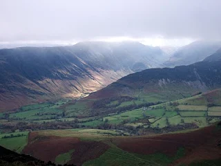
This way was steep though and hands were needed in a few places as easy rock passages were encountered. It was more that the rock was slippery than difficuly but the views were worth the extra effort and I soon found myself on a wide heathery ridge top with the wild scene of the head of the Newlands valley bounded by High Spy and Dale Head, contrasting with the wooded shores of Derwentwater beyond the fields and farmhouses of the dale below.

Ahead was the steep cone of Causey Pike , mist clinging to the summit crags. It reminded me from here, of a smaller and tamer version of the Matterhorn with the rocky bulge just below the summit. I passed the point where the main path reaches the ridge - Sleet Hause - and started up the ridge.

A good path led without difficulty up the ridge and I gained height quickly soon finding myself below the rocky section. The path heads more or less straight up this rocky dome and while the hands are certainly needed, the way up is much easier than it appears from below then - just as the steepness eases - you are on one of the finest summits in the region. The highest point is the top of the steep rocky bulge seen from below though as the rocks are surmounted one reaches a small grassy platform.

It was a shame that I had reached the cloud layer as the view - which had improved with height would have been excellent from this eagle's nest of a vantage point. The top of Causey Pike is made up of several - 5 I think - bumps which are visible in views of the fell from below. The path now led sucessively over these. The first one appears to be the highest but there's not much between it and the third one. There was no mistake about the route now - on along the ridge through a chill windblown fog towards the next peak - Scar Crags - itself invisible about a kilometre ahead.

The ridge widened for a while and a constructed raised pathway traversed some damp looking areas before a steady ascent brought me to the top of Scar Crags where the view matched that from Causey Pike exactly - a circle of turf and stones beyond which existed only a cold rushing blankness.

The path led on down the far side into the mist and I was soon at Sail Pass where this trail crosses the one linking Braithwaite and Buttermere. The logical circular route here branches right on the Sail Pass towards Braithwaite but with a nod in the direction of peak bagging I decided to ascend Sail before heading down that way. The summit is not much further and was one of the Wainwrights I hadn't climbed before. I had originally planned to go as far as Eel Crag aka Crag Hill but I had been there not so long ago in better weather than this and it would mean retracing my steps if I wanted to visit Outerside. Besides my planned descent of Crag Hill by the Shelf Route - also a fine route of ascent - from Coledale requires clear weather.

Heading up the easy slope to Sail on the wide path, the landscape subtly changed. Sprigs of heather and longer strands of grass beside the path became tinged with white hoar frost and the small patches of snow ceased to be soft. At 2400 feet I had reached the freezing level or 0 degree isotherm. Thanks to the mist I had also entered what aircraft pilots call icing conditions where cloud droplets freeze on contact with solid objects in this case clothing which is far less of a problem than the control surfaces of an aircraft. The forecast snow had not arrived though.

The top of Sail was a cheerless place in this weather and I set off back down to the pass where I emerged below the mist to the wild scene of upper Coledale with the ruined mine below the waterfall at its head. The cloud hid the surrounding summits from view and their rough slopes dropped from the mist. I was passed by 2 girls who had been on Sail and were also heading for Outerside which was the interesting looking cone shaped hill in front that was currently free from mist.

After I had eaten most of my lunch I set off down the track on the Coledale side in a roughly north easterly direction. This is an interesting path across the rough slopes of Scar Crags high above the valley and it led to more level ground where I branched off left towards Outerside. This was grassy terrain and became quite boggy for a while before I found solid ground that led easily up to the fine stony summit of Outerside. These smaller fells are often unjustly neglected yet they can be just as enjoyable to climb as the major fells. The 2 girls had headed up here but no-one else had. They must be doing the Wainwrights as well!

I walked down the ridge towards the expansive views of Keswick, Derwentwater and the lower slopes of Skiddaw and passed the 2 girls again - they must have thought I was following them! The ridge steepened down to a damp heathery plateau interlaced with many small paths. I kept to the right of Stile End - the hill ahead - and found a path that descended to the right where I arrived at the col between this and the next hill known simply as Barrow. The route over Outerside is longer but much more of a joy than the main path in the valley below. I would rejoin it lower down after conquering Barrow.

A clear path led onwards along the ridge and 10 minutes or so brought me to the top of Barrow - only 455m or 1493 feet but commanding a wonderful view of the vale of the Derwent as well as Newlands directly below in the fading light of late afternoon. There's no safe route straight down so to get down there I retraced my steps towards the col I had just left. Here I met the 2 girls again and they were doing the Wainwrights - why else would anyone be up here at this hour? They'd had a good day out but were now faced with a drive back to London - I did not envy them! They had been the only people I had seen since my descent to Sail Pass.

From the col I cut straight down the fellside where a small path joinrd up with the main one below on which I turned left down the valley. This path rounded the corner in the valley and followed the road along to where I was parked. I saw no-one along here either.

Pete Buckley November 2010

Summits >>> Causey Pike 637m/2090ft >>> Scar Crags 672m/2205ft >>> Sail 773m/2536ft >>> Outerside 568m/1864ft >>> Barrow 455m/1493ft

Essentials >>> Up 970m >>> Down 970m >>> How Far? 12km >>> Start and finish at the Newlands Road near Stair >>>

Friday 5 November 2010

A Short Walk from Honister

buttermere
Weather men and climatologists have a unit with which to measure how much sunshine a place receives or is likely to receive, known as the sunshine hour or sun hour. In the Lake District however as I emerge from Honister Youth Hostel - a cheery place of an evening in any weather - I propose that another unit be used, to be known as the sunshine minute. None of these were recorded yesterday nor would be today by the looks of things and if yesterday's rain had lacked commitment then today's was businesslike and determined in its efforts to discourage outdoor activities.

A wide gravel track led from the mine towards the dark misty outline of Honister Crag - the summit just in front of Fleetwith Pike - and I passed the turn off for Great Gable which ascends to the left. Nobody was out today and I had the misty fellsides and monochrome but atmospheric views to myself.

A little further on, the track forked and I took the left hand one - the other leading towards mine workings below Honister Crag. The track now lead more steeply up through a forlorn landscape of grey stone and damp heather to level out again on a rough heathery plateau with intermittent views to the fells of Ennerdale and the Great Gable area though banks of cloud drifted in front of their familiar outlines.

A short distance before some fresh mine workings where was parked a lonely looking digger - a faint path branched off to the right to avoid going through the workings themselves and re joined the track that led up over a rough landscape to the rocks marking the top of Honister Crag. Just before here I made a diversion to some old stone huts perched on the edge of the abyss their glassless windows overlooking the drifting mists that screened the screes of Dale Head opposite and road in the valley some 1500 feet below like some ancient mountain fortress standing guard over the pass.

From Honister Crag, a path meanders through the heather past a small tarn to climb the main summit of Fleetwith Pike overlooking the Buttermere Valley ahead. After the harsh landscape of the slate mines it's a surprisingly pleasant route that makes its way towards the vista of Buttermere and Crummock Water spread out below between Grasmoor and the High Stile Range. Venturing a short way down the ridge beyond the summit gives the best views, and seems to look straight down to Gatescarth farm in the valley below.

The rain in fact had almost stopped as I began my walk back to the pass but this was only a brief respite - it was raining again when I got there and continued to do so for the rest of the day.

This is a short walk of just over 3 miles return that is suitable for days such as this one when you don't always want to be out too long. In better weather it is even more rewarding with fine views down the Buttermere Valley to be had from the summit of Fleetwith Pike. The old mine huts near the top of Honister Crag are quite fascinating but take care on the edge - it is a sheer drop! For the peak bagger, Fleetwith Pike (648m/2126ft) is a Wainwright and a two thousander.
*
Pete Buckley October 2010
*
Summits >>> Fleetwith Pike 2126ft/648m

Tuesday 19 October 2010

A Circuit of Helvellyn from Thirlmere

grisedale_tarn
The path to Helvellyn from Wythburn Church was once one of the most popular ascent routes to that fell yet in recent times other ways to the summit have come more into favour. The route though is easy to follow and maintains interest throughout its course from the forested shores of Thirlmere to the top of England's third highest peak. My return route here was a circular finishing with a pleasant forest walk to the start point from Dunmail Raise - oh and for the peak bagger there are 4 Wainwrights on this one.

From the small church at Wythburn the signed path heads steeply up through the trees - mainly coniferous - to cross a forest road a short way uphill. There is a signpost here informing us that Helvellyn is straight across up the path on the opposite side. To the right is marked Dunmail Raise and left "Swirls" while Wythburn Church is signed back the way we've come - remember this for the last part of the walk!

The path continued steeply uphill leaving the trees for a moment and allowing views of the rugged wooded country on the far side of Thirlmere though the lake itself remained largely concealed below. The path climbed past a line of tall pines before veering right to enter a vast hollow in the hills above the woods.

With the beck down on the left, I followed the path - which is a constructed trail here - steeply up and back around to the right to gain a gap in the crags above on that side. The views along Thirlmere improved as I moved back in that direction though the distant views across the Lake District - which are usually impressive from here - were largely obscured by haze. There were signs of this clearing though as I got higher and Skiddaw stood out more clearly in the North as did the high ridges above me though cloud rolled over the top from the East from time to time.

The terrain above the crags is more open and the gradients easier and I made rapid progress along an easy path that slanted up towards the ridge emerging at the gap between Helvellyn and Nethermost Pike. Now it was an easy walk to the summit through the mist that blew across the ridge in the strong gusting easterly wind.

There were intermittent views from the cairn of Catstycam and Striding Edge and a ghostly prospect of Skiddaw seen through shifting mists but generally the cloud won and the views for which Helvellyn is known, remained elusive.

I now intended to follow the ridge in a southerly direction to Grisedale Tarn and make my way back via Dunmail Raise so I set off back in that direction, following the edge of the escarpment instead of the wide path coming up from Grasmere. There were surprisingly few people for a weekend when it wasn't raining though I did meet a couple who had ascended by Kepplecove Tarn (as it was - there is no tarn now) from Glenridding which is the route I describe in "Helvellyn the Quiet Way" and indeed they had found it quiet. We discussed the merits and hazards of descending by Striding Edge in this wind and they wisely opted for the route by Grisedale which is a nice walk. When I had come up by Keppelcove my intent to descend by Swirral Edge to Catstycam had been thwarted by gales. Neither route would pose a serious danger today - if care were taken - but why take the risk?

Crossing the wide summit of Nethermost Pike then the small grassy peak of Dollywaggon Pike I reached the steep descent to Grisedale Tarn which can be toilsome to climb on a warm day and was the reason I'd done the circuit this way around. If you're a peak bagger then these 2 summits are both Wainwrights and two thousanders though the way over them is far pleasanter than the wide tourist path regardless.

There were quite a few people making the ascent this way though and despite my less than favorable memories of the route on hot summer days it remains a popular way to Helvellyn. In descent it is enjoyable with Grisedale Tarn getting ever closer while the rough slopes of Fairfield rise opposite. The location if the tarn is wonderful, being a wild hollow in the mountains at the head of the long deep valley of Grisedale. It is miles from any road and is only accessible on foot or by mountain bike.

I followed the path around the tarn to the left rather than cut across to its right and found myself on the good path that climbed steadily a short distance to Grisedale Hause (pass). Here I ascended the steep ground facing me on the right of the pass to my last summit Seat Sandal. The path is excessively loose and steep lower down and the grass to the right is easier here. Having negotiated the steep section, it was simply a case of following the wall to my last summit of the day.

Seat Sandal is a fine viewpoint being separate from the rest of the fells and overlooking Grasmere on one side and the valley containing Thirlmere on the other - the best views of Grasmere are to be had from the cairn a little further on down the ridge. I had the summit to myself for a while until I was joined by fellow lone wanderer of the hills - a very pleasant girl who's name I didn't get but who had come up from Grasmere and was heading back via Fairfield and Great Rigg which sounds like another good circuit. She said her route up the ridge had been hard work - it does look pretty direct!

Leaving the wide views to the ravens, I set off roughly northwards aiming to the left of Dollywaggon Pike to descend a steep grassy slope to join a path that led down to the left following the stream. This track led down a wonderful mini gorge with rapids and waterfalls as the river made its way over rocky steps and through deep channels. This is the valley of Raise Beck and leads without difficulty - care in a few places if the rocks are wet - to the top of the road pass Dunmail Raise.

Thankfully there is a path that leads off from the road over the stone wall at a stile signposted to Wythburn so to the sound of 2 motorcyclists apparently attempting to set a new land speed record, I left the tarmac behind and followed the path through fields to end up back in the forest where I'd started. An enjoyable walk along a forest track - gained over a bridge across a river at the edge of the trees - brought me from views of Thirlmere through the trees into the deep greens of the woods and to the signpost I'd passed at the start of the walk. Those who were paying attention will remember that it points left from this trail down the hill to wythburn Church. If you miss the sign then - well I've not been that way but I guess it ends up at the King's Head pub where at least you can get a pint before walking all the way back.

Pete Buckley October 2010

Summits Helvellyn 950m/3117ft Nethermost Pike 891m/2923ft Dollywaggon Pike 858m/2815ft Seat Sandal 736m/2415ft

Essentials >>> Up 1040m >>> Down 1040m >>> How Far? 15.2km >>> Start and finish at Wythburn Church by Thirlmere (bus stop and small car park)

More walks and hikes on my homepage

Monday 11 October 2010

Grasmoor from Crummock Water

buttermere_lakeland
Rannerdale is an area of level cultivated ground effectively forming a break in the steep - often precipitous - mountainsides that fall to the eastern shores of Crummock Water. The valley is overshadowed by Grasmoor, Whiteless Pike and the lower but craggy Rannerdale Knotts and the circuit of these 3 fells which are all Wainwrights makes for a varied and interesting walk - after a challenging start. For the peak bagger there is opportunity to reach 2 more summits with little extra effort and more if you're feeling energetic!

Leaving what is the first of 2 car parks (free) when heading towards Buttermere along Crummock Water, I followed the path ascending the steep hillside towards a line of reddish scree that reached towards the ridgeline of Grasmoor almost 2500 feet overhead. The path soon became sketchy suggesting people had realised that an easier route to the summit of Grasmoor exists from the other car park but I continued to persevere with the few who chose this route which is called Red Gill and follows the small stream of that name.

After a few hundred feet of unrelenting steepness through grass and bracken then heather, the path eased in angle as I approached the foot of the scree run which is about 1000 feet from top to bottom. The retrospect to the rough flanks of Mellbreak across the lake and the Buttermere Fells beyond the craggy end of Rannerdale Knotts opened up as I ascended the scree and my upwards progress could be guaged against the fells opposite. The easiest way I found was by a small path partly hidden under the heather on the right of the stones. The scree itself is practicable but loose and unpleasant.

A lone buzzard wheeled over the rough hillsides above eyeing up a potential meal which struggled up through the rough heather and steepening ground. I kept going though and was soon far above the ridge of Mellbreak opposite with views of the approaching weather to the West. The unbroken amorphous grey of a weather front filled the sky beyond the lonely fells of Great Borne and starling Dodd while the high fells at the head of Buttermere began to disappear one by one. Great Gable - when one can see it - appears to rise from the Buttermere Valley from here but it in fact overlooks the next valley of Ennerdale.

My troubles were not over at the top of the line of scree - the ground became even steeper - a tangle of heather, patchy scree and rocky outcrops inclined at a 45 degree angle rose ahead, over 2000 feet above the flat green carpet of Rannerdale and the cold depths of Crummock Water below. The path too soon gave up the ghost suggesting this was where it was customary to give up - or become a meal for hungry birds. Three buzzards were now circling hopefully overhead and it was a case of picking one's way upwards and not slipping back too much. The ridgeline looked close but it was still further than it looked.

The last part of the ascent was up loose sliding scree and then thankfully, a series of easy shelves across rocky outcrops to emerge on the wide ridge buffeted by an icy wind. Several sheep stared at me with apparent amazement that anyone was mad enough to come up this way.

The diversion to Grasmoor End is worthwhile here - a short descent to the left for birds' eye views of Lanthwaite - but the windswept summit of Grasmoor lies a short way up a wide easy slope to the right. The top has a large wall shelter and a second smaller one overlooking the escarpment I had just ascended. The grey ceiling was not far overhead though and lower fells to the south were now hidden in mist. The wind now blew cold enough for me to don gloves and coat but at least the rain was holding off.

This is the highest point of the route and the rest is easy. I followed the path leading down a gentle gradient followed by a steeper descent to a curious green hollow in the fells where a crossroads in the pathways gives a choice of options. Ahead a wide path makes an easy ascent of Eel Crag (marked as Crag Hill on the OS map) and Wandope, (another Wainwright) is even easier to its right while to the left Hopegill Head is within reasonable distance. My route though lay along the equally easy path to the right which led gradually down to follow a ridge with views of Newlands Hause to surmount a small rise to the fine summit of Whiteless Pike where I rested and finished off lunch - it was now warmer than it had been on Grasmoor.

From Whiteless Pike an easy to follow and interesting track heads down towards Buttermere village in the valley below via some easy rocky sections just below the summit. This is the path to Buttermere if that is your destination but as I had left the car at Rannerdale, I turned right at the bottom of the main descent but still several hundred feet above the valley and followed a delightful path along the ridge to the right which rose gradually in a series of rocky outcrops and wide grassy swathes to the gnarly peak of Rannerdale Knotts. The smaller fells are often some of the best walks and this is no exception. Even though the rain was now coming down, this was the most enjoyable part of the walk with views of Crummock Water straight down to the left and the misted Buttermere Fells circling the head of the valley behind.

From the top of Rannerdale Knotts, the path continues on before bearing left and descending steeply over stone steps for some of the way down to the road alongside Crummock Water. Following this away from Buttermere brought me past the second car park and to where I was parked at the base of Grasmoor. As I removed my boots, a couple with one of those small yappy type dogs on a lead set off up the steep path I'd climbed earlier - they went for nearly a whole minute before coming back down - sensible!

There are easier ways onto Grasmoor and the surrounding fells but this is a good route if you are after a challenge on rough terrain and like the feeling that the hardest part of a walk is over with early on.

Pete Buckley October 2010

Summits Grasmoor 852m/2795ft Whiteless Pike 660m/2165ft Rannerdale Knotts 355m/1165ft (as described)

Essentials >>> Up 850m >>> Down 850m >>> How Far? 10.6km >>> Start and finish at Rannerdale by Crummock Water

Another good route to Grasmoor here.

Thursday 26 August 2010

Through the Coniston Fells

coniston_fells
This is a walk along the length of the Coniston Fells in the Furness region of South Lakeland. As described the walk takes in 5 Wainwrights though there are options to extend it to take in all 7 of the Coniston Fells - a long day - or shorten it into a circular route visiting 4 summits. My own chosen variation visits 5 tops including the remote summit of Grey Friar at the northern edge of the range, this being the only fell in the area I hadn't previously climbed.

Setting out along the stony track of the Walna Scar Road - a track closed to traffic - I passed the path turning right up the steep hill to Coniston Old Man - the Boo Tarn route. This is a quiet and pleasant way to that peak that is much to be preferred to the traditional way via Low water and it is described in full on my Coniston old Man page. The way is now signposted by where a quarry road leaves the Walna Scar route. There is more on the traffic free status of that route at the end of this post.

After three quarters of a mile I left the Walna Scar Track to follow a path up to the right leading past the deep blue waters of Goats Water, a mountain tarn beneath the soaring rocks of Dow Crag on its far shore where several rock climbers could be seen ascending the cliffs far above. Now the path climbed steeply over rough terrain to gain the col of Goats Hause which separates Dow Crag from the Old Man. Here groups of walkers rested after the warm steep ascent.

The steady stream of people now headed off to either one of these peaks though my route followed the fainter path that after the initial right turn branched off to the left to contour the slope at an easy angle towards Swirl How with my own objective of Grey Friar seen across the deep valley containing Seathwaite Tarn. This path simply saves climbing up over Brim Fell which marks the main ridge and would be my return route.

With little effort I reached the col before Swirl How and began the ascent again. The views now opened out to Levers Water down the opposite side of the ridge with Coniston Water below and the green expanse of Grizedale Forest beyond. After the false summit of Great How crags was passed I made my way - with the groups of walkers - over to the cairn marking the top of Swirl How. Though overtopped by a matter of a metre or 3 feet by Coniston Old Man, Swirl How is actually the main peak of the Coniston Fells and it is fom here that the ridges connect to each end of the group.

One such ridge falling in just north of an easterly line to connect with Wetherlam is the Prison Band and this is an option for a circular route. If you had ascended by the Boo Tarn - or Low Water for that matter - route to the Old Man and followed the ridge here, descending the Prison Band to Levers Hause and going down to Levers Water gives the choice of returning to the Walna Scar Road via "Boulder Valley" or continuing down to Coniston.

I had a rest and some more water on the top of Swirl How watching the various groups milling their way along the wide ridge - most were going no further than this - when I got chatting to a girl who came and sat on the next rock to my own. Turns out that she'd set off from Langdale that morning and had already climbed Pike o' Blisco and Cold Pike on the far side of the Wrynose road before arriving here via Grey Friar. Her plan was to continue to Dow Crag and the Old Man and return to Langdale via Wetherlam so climbing all of the Coniston Fells. Impressed? I was!

Jaqueline was doing the Wainwrights and had set off that day to see how many summits she could reach - a few more than I would today - but at least I had done most of them already! We compared Munros and Wainwrights for a while before heading off on our separate ways into the hills. What a thoroughly charming girl!

The way from here to the next summit, Great Carrs is simply a matter of a few minutes walk with spectacular views into the Central Lakes. The crowds had gone and as I set off for Grey Friar pretty much everyone had gone. Grey Friar stands in remote mountain country separate from the main Coniston Fells overlooking the beautiful and unspoilt Duddon Valley and the lonely country above Cockley Beck - Upper Eskdale and the Scafell Range which was topped with grey cloud - one of the finest views in the Lakes.

I finished my lunch on the summit in the chill wind that had sprung up before heading back. Another easy path contoured the hillside around to the right from the depression between Grey Friar anf Swirl How so avoiding re-ascending those fells I had just climbed. The path joined the ridge again just before the ascent to Brim Fell which was an easy steady climb past several cairns to the broad expanse of the summit. Despite the increased cloud, the air remained clear and the Isle of Man floated surreally over the top of Harter Fell. Coniston Old Man was only a short way from here and soon I had rejoined the tourists on its summit who milled around taking photos of each other by the trig point.

I strained my eyes looking across the silver expanse of the Irish Sea in search of Snowdon - yes perhaps a dark smudge was just visible on the edge of things. Occasionally one can see as far as the Welsh Mountains from the Lake District but it is not so common. No sign of my companion of earlier - she must already be on her way back by now.

I set off leaving the tourists to do touristy things and headed south towards the top of the Boo Tarn Route. A faint path was soon picked up and I followed it down to the Walna Scar Road. If descending by this route do not stray too far to the right - towards the valley containing Goats Water - the ground is much steeper with crags there. Once the path is found it becomes more obvious the further you go. In mist - which is most of the time at Coniston - it is perhaps better to go down by the normal way past Low Water. Here even the most navigationally challenged would struggle to lose their way. All in all I would rate this as a good day out in the hills.

Pete Buckley August 2010

Summits >>> Swirl How 802m/2632ft >>> Great Carrs 785m/2575ft >>> Grey Friar 773m/2536ft >>> Brim Fell 796m/2611ft >>> Coniston Old Man 803m/2635ft
Essentials >>> 860m/2820ft of climbing and descent >>> 15.4km or 9.6 miles of walking >>>
Start and finish at the sart of the Walna Scar Road or from Coniston >>> check out my homepage for more walks and hikes

Postscript: As I reached the car park there were 2 guys from ITV News filming at the start of the Walna Scar road. As it turns out they were covering the story that the road had - that very morning been closed to traffic. I had been under the impression that it was anyway but no - it had been opened and closed at regular intervals and todays news was the latest in the saga. The road goes to the Duddon Valley via a 2000 foot pass and driving over it would almost certainly result the destruction of your car but the issue here was use by 4 wheel drive vehicles and off road motor bikers.

My own view on this matter is clear - the road should remain for use by non motorised transport only with the exception of essential traffic related to the quarry, use by farmers and the mountain rescue service. There is more on this matter in an article I have published here

Wednesday 14 July 2010

The Caldbeck Fells

caldbeck_fells
Here is an easy circular walk of eight and a half miles into the Caldbeck Fells at the northern extremity of the Lake District. The walking is easy and generally on grass apart from a fascinating ravine walk and 4 summits - all Wainwrights - are reached. The route perhaps lacks the dramatic scenery of the central Lakes but the empty spaces and far reaching views that typify the Caldbeck Fells, you will have to yourself. The start is from just south of the small hamlet of Orthwaite reached up the minor road about 5 miles north of Keswick on the A591.

The previous day had been one of the warmest of the summer with temperatures in excess of 30C in the South of England and 26C at home 200m above sea level. This was not the case today however and the thermometer stood at 11 degrees while ragged grey clouds hid the top of Skiddaw and a thin rain blew in on the fresh north westerly wind. From the almost tropical warmth of yesterday the weather now reminded me of the damp chill of Reykjavik in Iceland which was hardly surprising really as that was where it was coming from.

Hood up, I set off through the gate opposite and up the bridleway on its far side. I was about seven and a half miles north of Keswick and just south of the hamlet of Orthwaite above Bassenthwaite Lake and the path here was signposted to Burn Tod though I'm not sure why because there's nothing there. After a short distance the path left the farm track (which goes to Dash Farm) and climbed gently up to the left across the slopes of the fell known as Great Cockup which has to be one of the funniest names ever given to a hill. After passing a small summit which is actually a great viewpoint, the path meandered its way along the slopes towards a great grassy hollow in the fells ahead with views on the right of the Dash Valley and falls. These remote hills are known as the Ulldale Fells and join up with the (slightly) better known Caldbeck Fells the northernmost range in Lakeland. The character of the area though is not typically Lakeland but has more in common with the Howgills or the Southern Uplands of Scotland - vast sweeping slopes and rounded summits, the exception here being the northern aspect of Skiddaw fronted by the shadowed crags of Bakestall and the spectacular Dash Falls.

My path descended into the hollow surrounded by clouded hills and at an area of tall foliage the path disappeared and the rain started up again with renewed vigour. I crossed a stream and by passed the reedy area to its right and just beond a ruined wall, the path was rediscovered up to the left. Here I entered an exciting steep sided ravine which was a change from the open grasslands but didn't stop the wind which funnelled up behind me. The path mainly keeps on the left side of the river on the ascent and though rough in a few places is not hard, climbing steadily up the ravine which makes for an interesting walk.

As the top is neared the ravine splits in 2 with the main river descending from the left branch while the right one is almost dry. A path does exit up to the left but the far easier way is to keep on up the right branch which soon ceases to be a ravine at all, emerging on the grassy ridge at the top. Here I turned left and followed a faint path up the wide ridge in dense mist buffeted by an icy wind and horizontal rain which - just for good measure - was mixed with face stinging hailstones.

After a cairn on the ridge, the path climbed again indicating that the cairn hadn't been the summit of Knott after all - the true top being revealed ahead as the cloud finally broke up around me giving tantalising glimpses of distant hills and wild empty spaces to the east. That was Skiddaw Forest and the Caldbeck Fells - Lakeland's Empty Quarter. It is very important if you come walking up here in visibility as bad as this not to get lost by heading too far east - the walk home will be too much for many!

Knott is the highest point of the Caldbeck Fells and the highest Lakeland fell north of Skiddaw and today it was positively arctic - after the recent heatwave this was one of the coldest days I remember walking in the UK in summer - it was now only 5 or 6 degrees more like winter really.

The view was revealed suddenly as the mists cleared away - blown at speed by the gale - and the rain ceased. My route lay to the north west to the grassy hump of Great Sca Fell which is nothing like its namesake above Wasdale though now the sun was out it was a very pleasant spot indeed. The only human for miles, I sat on the cairn which was the only rocky object in a sea of grass and admired the sweeping vista of the Cumbrian plain and the sands of the Solway backed by the hills of Scotland while all around the cloud shadows chased across the breezy heights.

Now my heading was west along another path and I soon descended a surprisingly steep though easy and grassy slope that was unseen from above. This led in due course to Meal Fell - for the peak baggers the third Wainwright though not a two thousander - whose summit is crowned by a fine stone shelter. Here I rested again and looked back to Great Sca Fell and the slope I had descended. There were 2 or 3 walkers coming down now appearing as ants half a mile away on the green expanse of Great Sca Fell.

To the West of Meal Fell is an interesting little pass known as Trusmadoor - a steep defile through the hills which I crossed to the South where it is easier. Now the path led steeply up a stony ridge on its far side until the gradient eased and followed the wide whaleback to the summit of Great Cockup - yes the name is still amusing but it's a good viewpoint as well!

From the far end of Great Cockup a descent to the left through heather soon picks up the track we started on earlier and a reluctant return to civilisation can be achieved by turning right when it is reached. Then again one could always bring a tent!

Summits >>> Knott 710m/2330ft >>> Great Sca Fell 651m/2136ft >>> Meal Fell 550m/1805ft >>> Great Cockup 526m/1726ft Essentials >>> 8.5 miles or 13.5km of walking >>> 1900 feet or 580m of ascent >>> Start and finish at Orthwaite >>>

Pete Buckley July 2010