Pages

Thursday 26 August 2010

Through the Coniston Fells

coniston_fells
This is a walk along the length of the Coniston Fells in the Furness region of South Lakeland. As described the walk takes in 5 Wainwrights though there are options to extend it to take in all 7 of the Coniston Fells - a long day - or shorten it into a circular route visiting 4 summits. My own chosen variation visits 5 tops including the remote summit of Grey Friar at the northern edge of the range, this being the only fell in the area I hadn't previously climbed.

Setting out along the stony track of the Walna Scar Road - a track closed to traffic - I passed the path turning right up the steep hill to Coniston Old Man - the Boo Tarn route. This is a quiet and pleasant way to that peak that is much to be preferred to the traditional way via Low water and it is described in full on my Coniston old Man page. The way is now signposted by where a quarry road leaves the Walna Scar route. There is more on the traffic free status of that route at the end of this post.

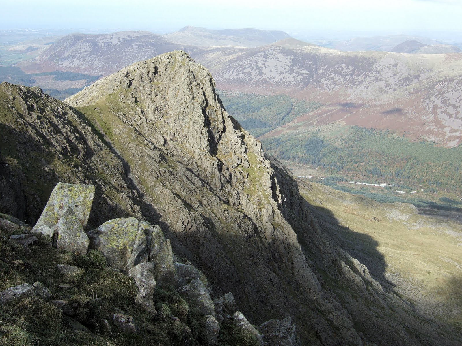
After three quarters of a mile I left the Walna Scar Track to follow a path up to the right leading past the deep blue waters of Goats Water, a mountain tarn beneath the soaring rocks of Dow Crag on its far shore where several rock climbers could be seen ascending the cliffs far above. Now the path climbed steeply over rough terrain to gain the col of Goats Hause which separates Dow Crag from the Old Man. Here groups of walkers rested after the warm steep ascent.

The steady stream of people now headed off to either one of these peaks though my route followed the fainter path that after the initial right turn branched off to the left to contour the slope at an easy angle towards Swirl How with my own objective of Grey Friar seen across the deep valley containing Seathwaite Tarn. This path simply saves climbing up over Brim Fell which marks the main ridge and would be my return route.

With little effort I reached the col before Swirl How and began the ascent again. The views now opened out to Levers Water down the opposite side of the ridge with Coniston Water below and the green expanse of Grizedale Forest beyond. After the false summit of Great How crags was passed I made my way - with the groups of walkers - over to the cairn marking the top of Swirl How. Though overtopped by a matter of a metre or 3 feet by Coniston Old Man, Swirl How is actually the main peak of the Coniston Fells and it is fom here that the ridges connect to each end of the group.

One such ridge falling in just north of an easterly line to connect with Wetherlam is the Prison Band and this is an option for a circular route. If you had ascended by the Boo Tarn - or Low Water for that matter - route to the Old Man and followed the ridge here, descending the Prison Band to Levers Hause and going down to Levers Water gives the choice of returning to the Walna Scar Road via "Boulder Valley" or continuing down to Coniston.

I had a rest and some more water on the top of Swirl How watching the various groups milling their way along the wide ridge - most were going no further than this - when I got chatting to a girl who came and sat on the next rock to my own. Turns out that she'd set off from Langdale that morning and had already climbed Pike o' Blisco and Cold Pike on the far side of the Wrynose road before arriving here via Grey Friar. Her plan was to continue to Dow Crag and the Old Man and return to Langdale via Wetherlam so climbing all of the Coniston Fells. Impressed? I was!

Jaqueline was doing the Wainwrights and had set off that day to see how many summits she could reach - a few more than I would today - but at least I had done most of them already! We compared Munros and Wainwrights for a while before heading off on our separate ways into the hills. What a thoroughly charming girl!

The way from here to the next summit, Great Carrs is simply a matter of a few minutes walk with spectacular views into the Central Lakes. The crowds had gone and as I set off for Grey Friar pretty much everyone had gone. Grey Friar stands in remote mountain country separate from the main Coniston Fells overlooking the beautiful and unspoilt Duddon Valley and the lonely country above Cockley Beck - Upper Eskdale and the Scafell Range which was topped with grey cloud - one of the finest views in the Lakes.

I finished my lunch on the summit in the chill wind that had sprung up before heading back. Another easy path contoured the hillside around to the right from the depression between Grey Friar anf Swirl How so avoiding re-ascending those fells I had just climbed. The path joined the ridge again just before the ascent to Brim Fell which was an easy steady climb past several cairns to the broad expanse of the summit. Despite the increased cloud, the air remained clear and the Isle of Man floated surreally over the top of Harter Fell. Coniston Old Man was only a short way from here and soon I had rejoined the tourists on its summit who milled around taking photos of each other by the trig point.

I strained my eyes looking across the silver expanse of the Irish Sea in search of Snowdon - yes perhaps a dark smudge was just visible on the edge of things. Occasionally one can see as far as the Welsh Mountains from the Lake District but it is not so common. No sign of my companion of earlier - she must already be on her way back by now.

I set off leaving the tourists to do touristy things and headed south towards the top of the Boo Tarn Route. A faint path was soon picked up and I followed it down to the Walna Scar Road. If descending by this route do not stray too far to the right - towards the valley containing Goats Water - the ground is much steeper with crags there. Once the path is found it becomes more obvious the further you go. In mist - which is most of the time at Coniston - it is perhaps better to go down by the normal way past Low Water. Here even the most navigationally challenged would struggle to lose their way. All in all I would rate this as a good day out in the hills.

Pete Buckley August 2010

Summits >>> Swirl How 802m/2632ft >>> Great Carrs 785m/2575ft >>> Grey Friar 773m/2536ft >>> Brim Fell 796m/2611ft >>> Coniston Old Man 803m/2635ft
Essentials >>> 860m/2820ft of climbing and descent >>> 15.4km or 9.6 miles of walking >>>
Start and finish at the sart of the Walna Scar Road or from Coniston >>> check out my homepage for more walks and hikes

Postscript: As I reached the car park there were 2 guys from ITV News filming at the start of the Walna Scar road. As it turns out they were covering the story that the road had - that very morning been closed to traffic. I had been under the impression that it was anyway but no - it had been opened and closed at regular intervals and todays news was the latest in the saga. The road goes to the Duddon Valley via a 2000 foot pass and driving over it would almost certainly result the destruction of your car but the issue here was use by 4 wheel drive vehicles and off road motor bikers.

My own view on this matter is clear - the road should remain for use by non motorised transport only with the exception of essential traffic related to the quarry, use by farmers and the mountain rescue service. There is more on this matter in an article I have published here

Wednesday 14 July 2010

The Caldbeck Fells

caldbeck_fells
Here is an easy circular walk of eight and a half miles into the Caldbeck Fells at the northern extremity of the Lake District. The walking is easy and generally on grass apart from a fascinating ravine walk and 4 summits - all Wainwrights - are reached. The route perhaps lacks the dramatic scenery of the central Lakes but the empty spaces and far reaching views that typify the Caldbeck Fells, you will have to yourself. The start is from just south of the small hamlet of Orthwaite reached up the minor road about 5 miles north of Keswick on the A591.

The previous day had been one of the warmest of the summer with temperatures in excess of 30C in the South of England and 26C at home 200m above sea level. This was not the case today however and the thermometer stood at 11 degrees while ragged grey clouds hid the top of Skiddaw and a thin rain blew in on the fresh north westerly wind. From the almost tropical warmth of yesterday the weather now reminded me of the damp chill of Reykjavik in Iceland which was hardly surprising really as that was where it was coming from.

Hood up, I set off through the gate opposite and up the bridleway on its far side. I was about seven and a half miles north of Keswick and just south of the hamlet of Orthwaite above Bassenthwaite Lake and the path here was signposted to Burn Tod though I'm not sure why because there's nothing there. After a short distance the path left the farm track (which goes to Dash Farm) and climbed gently up to the left across the slopes of the fell known as Great Cockup which has to be one of the funniest names ever given to a hill. After passing a small summit which is actually a great viewpoint, the path meandered its way along the slopes towards a great grassy hollow in the fells ahead with views on the right of the Dash Valley and falls. These remote hills are known as the Ulldale Fells and join up with the (slightly) better known Caldbeck Fells the northernmost range in Lakeland. The character of the area though is not typically Lakeland but has more in common with the Howgills or the Southern Uplands of Scotland - vast sweeping slopes and rounded summits, the exception here being the northern aspect of Skiddaw fronted by the shadowed crags of Bakestall and the spectacular Dash Falls.

My path descended into the hollow surrounded by clouded hills and at an area of tall foliage the path disappeared and the rain started up again with renewed vigour. I crossed a stream and by passed the reedy area to its right and just beond a ruined wall, the path was rediscovered up to the left. Here I entered an exciting steep sided ravine which was a change from the open grasslands but didn't stop the wind which funnelled up behind me. The path mainly keeps on the left side of the river on the ascent and though rough in a few places is not hard, climbing steadily up the ravine which makes for an interesting walk.

As the top is neared the ravine splits in 2 with the main river descending from the left branch while the right one is almost dry. A path does exit up to the left but the far easier way is to keep on up the right branch which soon ceases to be a ravine at all, emerging on the grassy ridge at the top. Here I turned left and followed a faint path up the wide ridge in dense mist buffeted by an icy wind and horizontal rain which - just for good measure - was mixed with face stinging hailstones.

After a cairn on the ridge, the path climbed again indicating that the cairn hadn't been the summit of Knott after all - the true top being revealed ahead as the cloud finally broke up around me giving tantalising glimpses of distant hills and wild empty spaces to the east. That was Skiddaw Forest and the Caldbeck Fells - Lakeland's Empty Quarter. It is very important if you come walking up here in visibility as bad as this not to get lost by heading too far east - the walk home will be too much for many!

Knott is the highest point of the Caldbeck Fells and the highest Lakeland fell north of Skiddaw and today it was positively arctic - after the recent heatwave this was one of the coldest days I remember walking in the UK in summer - it was now only 5 or 6 degrees more like winter really.

The view was revealed suddenly as the mists cleared away - blown at speed by the gale - and the rain ceased. My route lay to the north west to the grassy hump of Great Sca Fell which is nothing like its namesake above Wasdale though now the sun was out it was a very pleasant spot indeed. The only human for miles, I sat on the cairn which was the only rocky object in a sea of grass and admired the sweeping vista of the Cumbrian plain and the sands of the Solway backed by the hills of Scotland while all around the cloud shadows chased across the breezy heights.

Now my heading was west along another path and I soon descended a surprisingly steep though easy and grassy slope that was unseen from above. This led in due course to Meal Fell - for the peak baggers the third Wainwright though not a two thousander - whose summit is crowned by a fine stone shelter. Here I rested again and looked back to Great Sca Fell and the slope I had descended. There were 2 or 3 walkers coming down now appearing as ants half a mile away on the green expanse of Great Sca Fell.

To the West of Meal Fell is an interesting little pass known as Trusmadoor - a steep defile through the hills which I crossed to the South where it is easier. Now the path led steeply up a stony ridge on its far side until the gradient eased and followed the wide whaleback to the summit of Great Cockup - yes the name is still amusing but it's a good viewpoint as well!

From the far end of Great Cockup a descent to the left through heather soon picks up the track we started on earlier and a reluctant return to civilisation can be achieved by turning right when it is reached. Then again one could always bring a tent!

Summits >>> Knott 710m/2330ft >>> Great Sca Fell 651m/2136ft >>> Meal Fell 550m/1805ft >>> Great Cockup 526m/1726ft Essentials >>> 8.5 miles or 13.5km of walking >>> 1900 feet or 580m of ascent >>> Start and finish at Orthwaite >>>

Pete Buckley July 2010

Friday 25 June 2010

Wasdale to Glaramara

glaramara
This walk from Wasdale head visits 3 Wainwrights; Allen Crags, Glaramara and Great End, before returning by a little used shortcut through the Scafell Range. At just short of 13 miles with over 4000 feet of ascent it is long but varied throughout and gives contrasting views of much of central Lakeland.

Leaving Wasdale Head in the cool of early morning, I passed the small church of St Olaf and followed the lane between stone walls to Burnthwaite half a mile up the valley. Here the path was signposted left around the farm building before reaching the gap in the wall that marked the open fellside.

Studiously avoiding the rough and stony path that climbed to the left - the usual route to Sty Head - I kept to the right after the footbridge followed a quiet grassy path that kept close to the river of Lingmell Beck. The map shows this path keeping to the left or north of the beck and you can go that way but I crossed the stream just after a small copse of trees which is the old valley route to Sty Head.

The winding path climbed gently below spectacular views of Lingmell with its craggy ramparts falling to the deep cleft of Piers Gill while on the opposite side of the valley the scree slopes of Great Gable rose steeply past the Napes Crag to a jagged skyline over 2000 feet above. Several parties now slogged their wayb up the stony pathway opposite though I had this pleasant grassy walkway to myself.

My route curved up to the left of a rocky bluff and there was the summit of the pass with the stretcher box just ahead. Here I turned right and followed thewide track up past Sprinkling Tarn - the wettest place in England - to the wall shelter below Esk Hause passing en route the sombre northern crags of Great End. Where the path forks after the tarn take the left - the other goes directly to Esk Hause and Scafell Pike and going up there now would cause you to miss half of this route.

The views north down Borrowdale to Skiddaw and Blencathra were all of a sudden replaced by the jagged outline of the Langdale Pikes ahead as I reached the shelter. (Note - if in mist - this path passes just to the left of the shelter and not straight to it!) Turning left, a short easy climb brought me to the first summit of the day, that of Allen Crags.

Despite the infamous climate of this region, the sun shone warmly tempered only by a pleasant cooling breeze that gave almost perfect walking conditions. From allen Crags the path led at first downhill winding its way round rocky bluffs and across grassy swathes until I reached High House Tarn which is actually about 3 small pools facing an interesting perspective of the Langdale Pikes. Beyond, the route went up a small rocky groove and crossed a minor summit before a final depression and a steep climb to the right of crags ahead. Now 2 summits were seen ahead - the highest of Glaramara's several tops, the summit of the fell being the last one which also provides the best views.

The central position of Glaramara gives a unique perspective on the Central Lakes andhaving left the Wasdale fells behind I was now looking down on the green depths of Borrowdale and Derwentwater while behind the rugged peaks of Bowfell, Esk Pike and Great End made the skyline.

The return is by the same route and makes a round trip of three and a half miles with 1000 feet of ascent despite the 2 fells being of similar height - Deceptive but worth it for the views.

From here the quickest way back to Wasdale is to retrace one's steps to Sty Head but a more interesting though harder route is the one I now took. In what seemed no time at all after the up and down path I'd been on I was down past the stone shelter and almost up to Esk Hause on its far side - the wide path to Scafell Pike being completely without difficulty here. The pass actually links Eskdale and Borrowdale whereas the shelter which is sometimes referred to as Esk Hause is on the much more popular path from Langdale to Borrowdale or Wasdale. Sty Head links Wasdale and Borrowdale and yes - there are many people wandering these hills completely ignorant of these facts!

Once at the pass the view opened out into the wilds of upper Eskdale ahead and I followed the trail up to the left in the direction of Scafell Pike. The greatest joy of this motorway of a route is the look on the tourists' faces when they realise how far away the Pike still is! I consider heading there myself - but not for very long. Seven times is enough for anyone so I leave the path at the ridgeline and briefly head north again to the much nearer stony top of Great End. You can visit Scafell Pike - England's highest summit - on this walk by following the main path and descending by either Lingmell Col or Mickledore to Wasdale.

Great End has 2 summit cairns - the north western one with better views across Sty Head to Great Gable and the other which is considered the official summit. Both are about the same height. From the main summit - a rough tangle of boulders - I walked north a short way to where the best view was to be had. Overlooking the precipitous top of Great Gully the ground opens up to reveal Sprinkling Tarn a thousand feet below backed by the wooded vale of Borrowdale and the familiar outline of Skiddaw beyond Derwentwater - one of the finest mountain prospects in Lakeland. I watched the ant-like figures of walkers below on the path I'd ascended earlier before returning over the rough plateau to col above Calf Cove where I had left the main track.

There is a faint path down the far - or western - side of the ridge and it led down to where the ground steepened considerably though the steepness was walkable to where I met a stream on the right. Carefully I picked my way down the slope pausing to replenish my water bottles from the strem before continuing down to flatter ground in the grassy hollow of Calf Cove below.

A good spot this was - an unexpected pasture watched over by soaring crags and hidden from below. I followed faint traces of path over easy grass to the left of the rocky feature called Round How and skirted a marshy level at its foot then there just below was the Corridor Route path which I followed around the rocky head of Piers Gill, the vast ravine I'd observed from below that morning - seemed a long time ago now!

Where the main path climbed off up to the left, I followed a lesser trail which soon climbed beside a ruined stone wall to end up at Lingmell Col a wide expanse of rough tussock country between the Pike and Lingmell and crossing it brought me within sight of Wastwater sparkling in the West under the bright afternoon sun. joining the main path descending ahead there were views of the sublime rock walls of Pikes Crag above and Scafell Crag across the rocky combe known as Hollow Stones. These stony fastnesses took on a harsh aura inthe sunlight as if deprived of their customary garb of damp grey mist.

The descent from Lingmell Col is simply a matter of following the constructed pathway downhill - it is knee jarring and unpleasant after a long day though not as unpleasant as ascending this way in the hot sun. Near the bottom of the incessant gradient just after the path crosses the river where 2 streams meet the track splits in 2. If you are based at or near the National Trust campsite in Wasdale then you want the left one as that is where it duly leads. I wasn't so took the right which rounded the ridge and led down through scattered trees to Wasdale Head.

Summits >>> Allen Crags 785m/2575ft >>> Glaramara 783m/2569ft >>> Great End 910m/2985ft
Essentials >>> 12.5 miles or 21km of walking >>> 4100 feet or 1250m of ascent >>> Start and finish at Wasdale Head >>>
Pete Buckley June 2010


Friday 18 June 2010

The High Stile Ridge


buttermere

I had had breakfast and was out of the youth hostel by 8.30 am walking in the cool morning air down the empty road to Buttermere Village. Passing the Fish Hotel I followed the track between hedges across the level fields towards the lake. From here in this light, High Stile appeared of alpine proportions, its soaring crags towering skywards from the grassy meadows I was crossing. Buttermere Lake too provided a stunning view over its mirror calm water to the head of the valley appearing like a Norwegian fiord below the vast mountain wall to the South.
The path crossed the outflow from Buttermere by a footbridge and entered the forest on its far side. Here the cascade of Sour Milk Gill descends from the forested slopes above but my path climbed steeply through the trees well to its left. It was warm climbing through the woods in the still air and I had to keep stopping to cool off every 10 minutes. Above the trees and the view opened out of Buttermere - now a long way below - with Grasmoor and Robinson hanging in the clear air across the valley while the path became even steeper turning into stone steps going straight up the slope. As the slope eased off and the path tracked back to the right across the slope, it became cooler and the view now included Crummock Water down the valley.

The route now follows an easier section passing above the Top of the rocky ravine containing Sour Milk Gill to reach Bleaberry Tarn in its hollow below High Stile and Red Pike. The Tarn is is invisible until you reach it and I was surprised to find someone fly fishing here at this early hour. He reckoned that there were trout in there so I wished him good luck and carried on up more stone steps leading up to Red Pike. The steps are a bit of a grind but the last part has some excitement turning into an easy scramble up the steep summit of Red Pike always with stunning views and a sense of height behind.

I now put my coat on as the wind was no longer warm as I admired the view from Red Pike. The forests of Ennerdale surrounded Ennerdale Water over the far side while the West Cumbria plain stretched away to the Solway Firth with Scotland's Galloway Hills beyond. The rugged Pillar with Great Gable and the Scafells beyond were topped by grey cloud though we remained clear here.

In contrast to the steep ascent, gentle mainly grassy slopes led towards High Stile and only the last part of the ascent to its summit became rough again but this was what the rest of the route would be like. These mountains are composed of hard volcanic rock and their slopes are typified by acres of sharp shifting stones and the rocky escarpment falling away - often vertically - in gullies and butresses on the Buttermere side. It's a fantastic ridge walk but there's no way off for the walker without a paraglider between Red Pike and High Crag!

The cloud scraped the top of High Stile and the wind was chilly registering 9C on my rucksack thermometer as I ate my lunch before continuing on a rough up and down ridge towards High Crag at its eastern end. The highest point of High Stile by the way appears to be the first cairn you reach - there being another a 5 minute walk beyond it on a level plateau.

The weather improved with the cloud lifting and the Sun emerging as I reached High Crag - the most impressive of the 3 summits if the lowest. The wilds of Ennerdale lay below with Pillar opposite while the end of the ridge fell away in spectacular fashion with the rocky towers of Haystacks below. There's a track leading along Ennerdale to Black Sail Youth Hostel - 7 milles or so from the road - that would make a good bike ride by the looks of it. I'll give it a try and let you know.

The path from High Crag now descends the feature known as Gamlin End - a steep eroded slope of sliding stones and holdless gravel. There was in fact only one place where bottom and ground made contact but the 2000 foot drop to the Buttermere Valley isn't quite so pretty when one is sliding downhill towards it! It wasn't as bad as it sounds though - the slope went into a bank of stones that would prevent anyone falling down the slope and soon I was descending the tight zig zags of a stone pathway.

A short while later I was resting on a much more comfortable rocky shelf overlooking the last descent to Scarth Gap - the pass linking Buttermere and Ennerdale. People milled below on their way to the popular Haystacks and I opted to climb it on a quieter day. The weather was perfect - warm but not hot and blue sky now framed the fells at the head of Ennerdale having replaced their grey cloud caps. I set off down to the pass where I was greeted by a mountain biker carrying his machine over the rocky ground. In my view a route ceases to be bikable if you can't ride your bike over it. I'm loath to push a bike up a hill let alone carry it!

Lower down I met 2 more cyclists who said their guide book had recommended this as a route. I don't know which book they were using but I told them Ennerdale would be good but not not perhaps by this path and asked if the guy up ahead was with them.

"oh Yeah" they replied, "but he's extreme!"

Turning left at the bottom of Scarth Gap brought me onto the Buttermere lakeside track which was definitely more suited to bikes. This track follows the south shore of Buttermere opposite the one I'd been on yesterday and is even easier being passable to pushchairs and toddlers for all of its length. In fact it seemed that most of the visitors to Buttermere had decided to walk or push their prams along here today.

Through the pleasant coolness of Birtness Wood and back again to the Fish Hotel which I resisted a second time though - failing to also resist the Bridge Hotel - popped in for a pint as they had Black Sheep on tap - a particularly good beer!

Summits >>> Red Pike 755m/2477ft >>> High Stile 807m/2648ft >>> High Crag 744m/2441ft

Essentials >>> 7.5 miles or 12km of walking >>> 2600 feet or 800m of ascent >>> Start and finish at Buttermere Village >>>

Pete Buckley September 2009

Pillar from Wasdale Head

ennerdale


Half past Eight saw me walking alone up the valley of Mosedale in the chill shadow of the valley while above, the tops of the higher hills were bathed in a golden glow and behind me Scafell jutted above the intervening fells like a dark tooth outlined against the rising sun. At this hour there is a quality of light that just seems to fade away as the day goes on.

I had had an early breakfast and set off as it was too cold to sit around - even now it was only 3 degrees C and while I was warm walking, the tips of my fingers tingled in the cold air. My route had turned left in front of the shop and right after passing the entrance to the bar at the Wasdale Head Inn before leading through trees beside the stream - you don't cross the stream by the pub - and over a stile to enter Mosedale.Now my first objective - Pillar - towered ahead while the impossibly steep slopes of Kirk Fell rose to my right. The track was at first fairly level before it climbed to cross a river then ascended by zig zags more steeply for a couple of hundred feet.

The way to Black Sail Pass now lay ahead through a high valley in a wonderful stillness broken only by the sound of distant streams. I ignored the short cut which misses out the pass and followed this before climbing the last bit to where the top of the pass was lit by the rising Sun and I crossed into a world of sunlight and warmth with the vast space of Upper Ennerdale ahead.
The path to Pillar leads to the left from the Black Sail, passing a small tarn and keeping just below the ridge at first though a short diversion to Looking Stead - one of the best vantage points in the Western Fells - iswell worthwhile. After Looking stead the ridge climbs in a series of steps with 2 sections of easy scrambling each followed by swathes of sheep cropped turf before the final climb with spectacular views down some precipitous gullies on the right. The summit appears all of a sudden as the final rise is topped.

The top of Pillar is a wide flat space unexpected from below. The best views are to be had from the cairn on its northern edge where the rocky escarpment overlooks the River Liza flowing through Ennerdale's woodlands to Ennerdale Water 2500 feet below. A path leads down towards the top of Pillar Rock and for any exploration of that side of the mountain it should be stuck to - the slope being precipitous. Pillar Rock itself is no place for walkers!

Leaving Pillar, I set off down the path towards Wind Gap and Scoat Fell which became rougher and stonier the further down I went until I reached the ridge known as Wind Gap - not to be confused with Windy Gap which is the one between Great Gable and Green Gable. There is surprisingly an ascent route to this high col from Wasdale Head but it doesn't look like fun - very steep loose scree most of the way by the look of it! The decent was followed by a marginally easier ascent over the summit of Black Crag - not a separate fell in Wainwright's list but a fine top nontheless with its cairn perched near the cliff edge - and a grassy stroll to the wall running along the top of Scoat Fell.

Wainwright describes the walk along the narrow ridge to the intriguingly named Steeple as "Ten enjoyable minutes" and that's exactly what it is. The ridge is in a sensational position jutting out over the precipitous Ennerdale side of the fells and the small summit of steeple gives almost a bird's eye view of the shadowed northern crags of the range dropping to the verdant Ennerdale valley.

One day in November me and Jacqui had it to ourselves - a day when the snow clung to the ledges and whitened the tops and the distant Scottish hills stood out as clear and white across the Solway Firth...

Today haze hid the distant prospects and several people milled around up here but it is still one of the best places in the Lake District to have lunch! Reluctantly leaving, I recrossed the ridge - which presents no difficulty if the path is kept to - and returned to Scoat Fell. Up until now - apart from my solitary walk to Black Sail that morning - there had been a steady stream of walkers but as I headed west down the broad ridge towards the rounded form of Haycock they thinned out to just the occasional group. The far western fells here have a remoter feel than the popular summits closer to the head of Wasdale.

Haycock was a steady climb with the leg muscles starting to realise how far I'd already walked and its wide stony summit revealed open views to the Irish Sea and a hazy Isle of Man across the West Cumbria Plain and the empty valley of the River Bleng which streched away towards the coast. How many of the tourists in Bowness and Ambleside have even heard of the River Bleng?

The home stretch of my route lay back to the col before Haycock and down an equally remote valley to the South. I had the fells to myself once more as I descended the valley of Nether Beck which would take me back to the shores of Wastwater by Nether Beck Bridge. The path here was still easy to follow but had clearly seen much less use than the previous trails I'd been on. It led down grassy fellsides below craggy outcrops and past a destinctive perched boulder over to the right. Always downhill, now through bracken besides the tumbling stream of Nether Beck, the route passed a waterfall and crossed the stream coming down from the right to follow a ravine below on the left before the first trees indicated I was approaching the valley. A slightly damp short cut is possible to the bridge and cuts off a section of road if Wasdale Head is the destination but don't try and cross the beck as it's a steep drop down and the bridge is far easier and drier.

The road walk was soon over and I was back at the Green having walked 21 km or nearly 14 miles which is a bit more than my usual 8-10 miles - I deserved that pint in the Head!
Summits >>> Pillar 892m/2927ft >>> Scoat Fell 841m/2759ft >>> Steeple 819m/2687ft >>> Haycock 797m/2615ft


Essentials >>> 13.5 miles or 21km of walking >>> 3550 feet or 1080m of ascent >>> Start and finish at Wasdale Head >>> Here's the route up Pillar from Buttermere
Pete Buckley October 2009

Thursday 17 June 2010

Walking in the Lake District - Kirkstone to Ambleside

lakeland_fells


From the top of Kirkstone Pass, I followed the path that leaves the car park opposite the Kirkstone Inn at its far end. The slope ahead was daunting - a vast wall of screes and crags that rose still over a thousand feet above. This was the fell known as Red Screes and it's well named as the tongues of scree descending below the cliffs do indeed have a reddish tint to them. I was setting out to walk from Kirkstone to Ambleside via Scandale Pass and Dove crag which is a walk of nearly seven and a half miles or about 12km. The route takes in 5 Wainwrights - the Lakeland fells classified by AW Wainwright - Red Screes, Little Hart Crag, Dove Crag, High Pike and Low Pike with the option for the dedicated peak bagger to divert to High Hartsop Dodd which makes the walk 9 miles.


Despite the fearsome appearance of Red Screes, the path finds a steep but easy way through the obstacles and stone steps have been constructed up much of the route making it less rough than when I was last here. The only remotely tricky part was where the track veered left across a wide ledge to a short scramble but the route is marked with an arrow painted on the rock which if followed avoids any difficulties. I was soon stood on the summit admiring the breathtaking views of Lakeland and sheltering from the cold wind behind the cairn. My route ahead could clearly be seen and I began the descent heading in a north westerly direction towards Dove Crag. Bearing too far to the North will take you down the ridge leading to Middle Dodd and would require retracing your steps to continue the route. My current heading led down easy slopes towards the attractive castle like twin summits of Little Hart Crag which rose across Scandale Pass.

The path crossed the Scandale Pass track and climbed the open grassy slopes opposite and where it tended to head off to the left towards Dove Crag I diverted to the right to Little Hart Crag which is a fine summit - the first craggy knoll is the highest point - with spectacular views of the craggy eastern side of the Fairfield range. In the shelter of the cairn was a perfect lunch spot where I could occasionally hear parties of fellwalkers passing below on the path to Patterdale and Brothers Water though no-one came up the last fifty feet or so to the summit. From Little Hart Crag I headed down the main path to High Hartsop Dodd - an easy walk that gave good views of the fells around the top of Ullswater before retracing my steps and continuing on my way to Dove Crag. this diversion would only be recommended if you havn't visited High Hartsop Dodd - it isn't really on the way!

The route to Dove Crag is a wide path through grassy terrain but - with care - a diversion to the right will give impressive views down the precipitous crags overlooking Dovedale - an almost comletely unspoiled valley hidden in this particularly beautiful area of eastern Lakeland and a microcosm of what the Lake District was like in years gone by. There is no way down here though so don't try unless you are a proficient climber and have a rope to belay with. Certain death awaits efforts to scramble down unroped!

From this flattish area the route begins a steady ascent which emerges on the south ridge of Dove Crag, the summit being a short walk to the right up the broad ridge. I ate the last of my food here wrapped up against the freezing wind before setting off on the last leg of my walk. If you havn't been here before then a diversion of about 400m to the North gives spectacular views of Dovedale from the top of the crag after which the fell was named. I had so I didn't on this occasion.

Wainwright describes the walk from Dove Crag to High pike as the easiest mile in Lakeland and it is though this fact didn't stop me from slipping and falling ungracefully on my backside after 10 minutes. The gradient though is just right for walking down - enough slope to walk down with no effort yet not so steep that you have to slow yourself down. On towards Windermere which stretched away in front, barely rising over the summit of High Pike before making a steeper descent with the stone wall on my right.

The weather became steadily warmer as I lost height with the wind losing its chill. Low Pike rose just to the right of the path and I scrambled up to where the summit rocks and cairn nestled against the wall providing an interesting and comfortable perch on which to enjoy a banana and some water. Lower down the ridge was steep for a while as I followed the wall which was something of a feat of engineering descending the craggy ridge. A little lower still and trees began to return to the landscape which became softer and less rugged as Ambleside and the valley were approached. The cold wind had now gone but spots of rain were starting to fall from a grey sky.

If the ridge is kept to there is an awkward rock step to negotiate which is easier going up. It can be avoided by following the path to the left where it forks. Heading down through scattered trees on what was now a cart track I presently arrived at a bridge over the rushing waters of Scandale Beck which was pleasantly located in lush woodland and a short walk down a lane brought me into the busy centre of Ambleside.

This walk is ideal for anyone based in Ambleside even without transport as a regular bus service crosses Kirkstone and the start of the walk. As described it is about 9 miles in length, involves 2700 feet of ascent and 4050 feet of downhill. for the peak bagger the route visits 6 of Wainwright's summits. Not including High Hartsop Dodd does shorten the walk somewhat.


Summits: Red Screes 776m/2546ft; Little Hart Crag 637m/2090ft; High Hartsop Dodd (optional)519m/1703ft; Dove Crag 792m/2598ft; High Pike 656m/2152ft; Low Pike 508m/1667ft


Essentials >>> 7.5 miles or 12km of walking >>> 2700 feet or 830m of ascent >>> 4050 feet or 1230m of descent >>> Start at Kirkstone Pass and finish at Ambleside 
Pete Buckley May 2010