Pages

Showing posts with label travel. Show all posts

Friday 18 June 2010

Pillar from Wasdale Head

ennerdale


Half past Eight saw me walking alone up the valley of Mosedale in the chill shadow of the valley while above, the tops of the higher hills were bathed in a golden glow and behind me Scafell jutted above the intervening fells like a dark tooth outlined against the rising sun. At this hour there is a quality of light that just seems to fade away as the day goes on.

I had had an early breakfast and set off as it was too cold to sit around - even now it was only 3 degrees C and while I was warm walking, the tips of my fingers tingled in the cold air. My route had turned left in front of the shop and right after passing the entrance to the bar at the Wasdale Head Inn before leading through trees beside the stream - you don't cross the stream by the pub - and over a stile to enter Mosedale.Now my first objective - Pillar - towered ahead while the impossibly steep slopes of Kirk Fell rose to my right. The track was at first fairly level before it climbed to cross a river then ascended by zig zags more steeply for a couple of hundred feet.

The way to Black Sail Pass now lay ahead through a high valley in a wonderful stillness broken only by the sound of distant streams. I ignored the short cut which misses out the pass and followed this before climbing the last bit to where the top of the pass was lit by the rising Sun and I crossed into a world of sunlight and warmth with the vast space of Upper Ennerdale ahead.
The path to Pillar leads to the left from the Black Sail, passing a small tarn and keeping just below the ridge at first though a short diversion to Looking Stead - one of the best vantage points in the Western Fells - iswell worthwhile. After Looking stead the ridge climbs in a series of steps with 2 sections of easy scrambling each followed by swathes of sheep cropped turf before the final climb with spectacular views down some precipitous gullies on the right. The summit appears all of a sudden as the final rise is topped.

The top of Pillar is a wide flat space unexpected from below. The best views are to be had from the cairn on its northern edge where the rocky escarpment overlooks the River Liza flowing through Ennerdale's woodlands to Ennerdale Water 2500 feet below. A path leads down towards the top of Pillar Rock and for any exploration of that side of the mountain it should be stuck to - the slope being precipitous. Pillar Rock itself is no place for walkers!

Leaving Pillar, I set off down the path towards Wind Gap and Scoat Fell which became rougher and stonier the further down I went until I reached the ridge known as Wind Gap - not to be confused with Windy Gap which is the one between Great Gable and Green Gable. There is surprisingly an ascent route to this high col from Wasdale Head but it doesn't look like fun - very steep loose scree most of the way by the look of it! The decent was followed by a marginally easier ascent over the summit of Black Crag - not a separate fell in Wainwright's list but a fine top nontheless with its cairn perched near the cliff edge - and a grassy stroll to the wall running along the top of Scoat Fell.

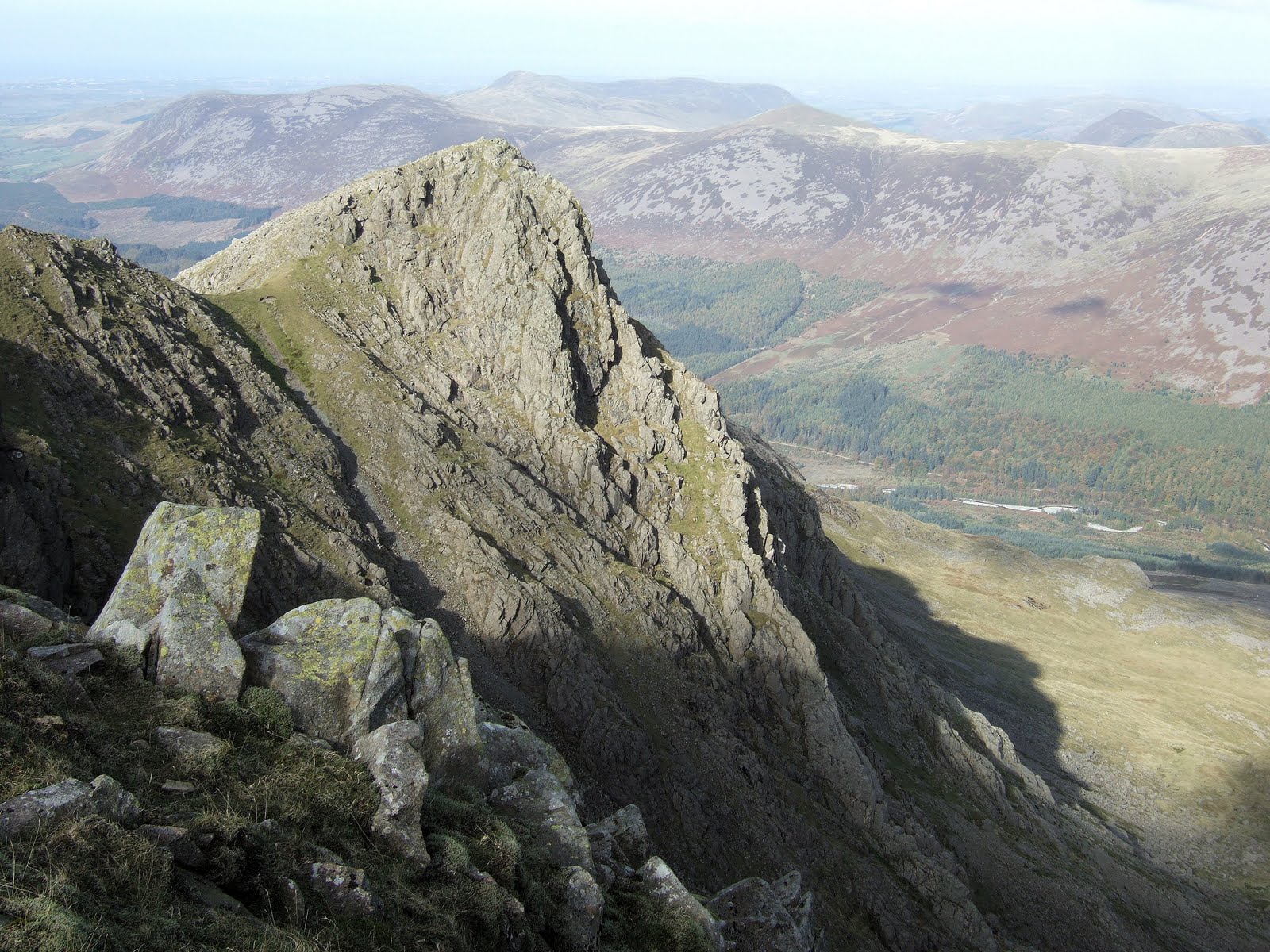
Wainwright describes the walk along the narrow ridge to the intriguingly named Steeple as "Ten enjoyable minutes" and that's exactly what it is. The ridge is in a sensational position jutting out over the precipitous Ennerdale side of the fells and the small summit of steeple gives almost a bird's eye view of the shadowed northern crags of the range dropping to the verdant Ennerdale valley.

One day in November me and Jacqui had it to ourselves - a day when the snow clung to the ledges and whitened the tops and the distant Scottish hills stood out as clear and white across the Solway Firth...

Today haze hid the distant prospects and several people milled around up here but it is still one of the best places in the Lake District to have lunch! Reluctantly leaving, I recrossed the ridge - which presents no difficulty if the path is kept to - and returned to Scoat Fell. Up until now - apart from my solitary walk to Black Sail that morning - there had been a steady stream of walkers but as I headed west down the broad ridge towards the rounded form of Haycock they thinned out to just the occasional group. The far western fells here have a remoter feel than the popular summits closer to the head of Wasdale.

Haycock was a steady climb with the leg muscles starting to realise how far I'd already walked and its wide stony summit revealed open views to the Irish Sea and a hazy Isle of Man across the West Cumbria Plain and the empty valley of the River Bleng which streched away towards the coast. How many of the tourists in Bowness and Ambleside have even heard of the River Bleng?

The home stretch of my route lay back to the col before Haycock and down an equally remote valley to the South. I had the fells to myself once more as I descended the valley of Nether Beck which would take me back to the shores of Wastwater by Nether Beck Bridge. The path here was still easy to follow but had clearly seen much less use than the previous trails I'd been on. It led down grassy fellsides below craggy outcrops and past a destinctive perched boulder over to the right. Always downhill, now through bracken besides the tumbling stream of Nether Beck, the route passed a waterfall and crossed the stream coming down from the right to follow a ravine below on the left before the first trees indicated I was approaching the valley. A slightly damp short cut is possible to the bridge and cuts off a section of road if Wasdale Head is the destination but don't try and cross the beck as it's a steep drop down and the bridge is far easier and drier.

The road walk was soon over and I was back at the Green having walked 21 km or nearly 14 miles which is a bit more than my usual 8-10 miles - I deserved that pint in the Head!
Summits >>> Pillar 892m/2927ft >>> Scoat Fell 841m/2759ft >>> Steeple 819m/2687ft >>> Haycock 797m/2615ft


Essentials >>> 13.5 miles or 21km of walking >>> 3550 feet or 1080m of ascent >>> Start and finish at Wasdale Head >>> Here's the route up Pillar from Buttermere
Pete Buckley October 2009

Thursday 17 June 2010

Walking in the Lake District - Kirkstone to Ambleside

lakeland_fells


From the top of Kirkstone Pass, I followed the path that leaves the car park opposite the Kirkstone Inn at its far end. The slope ahead was daunting - a vast wall of screes and crags that rose still over a thousand feet above. This was the fell known as Red Screes and it's well named as the tongues of scree descending below the cliffs do indeed have a reddish tint to them. I was setting out to walk from Kirkstone to Ambleside via Scandale Pass and Dove crag which is a walk of nearly seven and a half miles or about 12km. The route takes in 5 Wainwrights - the Lakeland fells classified by AW Wainwright - Red Screes, Little Hart Crag, Dove Crag, High Pike and Low Pike with the option for the dedicated peak bagger to divert to High Hartsop Dodd which makes the walk 9 miles.


Despite the fearsome appearance of Red Screes, the path finds a steep but easy way through the obstacles and stone steps have been constructed up much of the route making it less rough than when I was last here. The only remotely tricky part was where the track veered left across a wide ledge to a short scramble but the route is marked with an arrow painted on the rock which if followed avoids any difficulties. I was soon stood on the summit admiring the breathtaking views of Lakeland and sheltering from the cold wind behind the cairn. My route ahead could clearly be seen and I began the descent heading in a north westerly direction towards Dove Crag. Bearing too far to the North will take you down the ridge leading to Middle Dodd and would require retracing your steps to continue the route. My current heading led down easy slopes towards the attractive castle like twin summits of Little Hart Crag which rose across Scandale Pass.

The path crossed the Scandale Pass track and climbed the open grassy slopes opposite and where it tended to head off to the left towards Dove Crag I diverted to the right to Little Hart Crag which is a fine summit - the first craggy knoll is the highest point - with spectacular views of the craggy eastern side of the Fairfield range. In the shelter of the cairn was a perfect lunch spot where I could occasionally hear parties of fellwalkers passing below on the path to Patterdale and Brothers Water though no-one came up the last fifty feet or so to the summit. From Little Hart Crag I headed down the main path to High Hartsop Dodd - an easy walk that gave good views of the fells around the top of Ullswater before retracing my steps and continuing on my way to Dove Crag. this diversion would only be recommended if you havn't visited High Hartsop Dodd - it isn't really on the way!

The route to Dove Crag is a wide path through grassy terrain but - with care - a diversion to the right will give impressive views down the precipitous crags overlooking Dovedale - an almost comletely unspoiled valley hidden in this particularly beautiful area of eastern Lakeland and a microcosm of what the Lake District was like in years gone by. There is no way down here though so don't try unless you are a proficient climber and have a rope to belay with. Certain death awaits efforts to scramble down unroped!

From this flattish area the route begins a steady ascent which emerges on the south ridge of Dove Crag, the summit being a short walk to the right up the broad ridge. I ate the last of my food here wrapped up against the freezing wind before setting off on the last leg of my walk. If you havn't been here before then a diversion of about 400m to the North gives spectacular views of Dovedale from the top of the crag after which the fell was named. I had so I didn't on this occasion.

Wainwright describes the walk from Dove Crag to High pike as the easiest mile in Lakeland and it is though this fact didn't stop me from slipping and falling ungracefully on my backside after 10 minutes. The gradient though is just right for walking down - enough slope to walk down with no effort yet not so steep that you have to slow yourself down. On towards Windermere which stretched away in front, barely rising over the summit of High Pike before making a steeper descent with the stone wall on my right.

The weather became steadily warmer as I lost height with the wind losing its chill. Low Pike rose just to the right of the path and I scrambled up to where the summit rocks and cairn nestled against the wall providing an interesting and comfortable perch on which to enjoy a banana and some water. Lower down the ridge was steep for a while as I followed the wall which was something of a feat of engineering descending the craggy ridge. A little lower still and trees began to return to the landscape which became softer and less rugged as Ambleside and the valley were approached. The cold wind had now gone but spots of rain were starting to fall from a grey sky.

If the ridge is kept to there is an awkward rock step to negotiate which is easier going up. It can be avoided by following the path to the left where it forks. Heading down through scattered trees on what was now a cart track I presently arrived at a bridge over the rushing waters of Scandale Beck which was pleasantly located in lush woodland and a short walk down a lane brought me into the busy centre of Ambleside.

This walk is ideal for anyone based in Ambleside even without transport as a regular bus service crosses Kirkstone and the start of the walk. As described it is about 9 miles in length, involves 2700 feet of ascent and 4050 feet of downhill. for the peak bagger the route visits 6 of Wainwright's summits. Not including High Hartsop Dodd does shorten the walk somewhat.


Summits: Red Screes 776m/2546ft; Little Hart Crag 637m/2090ft; High Hartsop Dodd (optional)519m/1703ft; Dove Crag 792m/2598ft; High Pike 656m/2152ft; Low Pike 508m/1667ft


Essentials >>> 7.5 miles or 12km of walking >>> 2700 feet or 830m of ascent >>> 4050 feet or 1230m of descent >>> Start at Kirkstone Pass and finish at Ambleside 
Pete Buckley May 2010