Pages

Tuesday, 8 October 2013

Walking in the Lake District - Buttermere and Haystacks

Despite a modest altitude of 597m or 1962 feet; Haystacks; which rises above Buttermere, is probably one of the most popular ascents in all the Lake District. The fell's popularity is well deserved and stems from its rugged nature and easy access from Buttermere as well as the fact that it was among the favorites of Wainwright; whose guidebooks to the Lakes are still - and probably always will be - without compare. The summit with its little tarns and rugged outcrops was in fact the author's final resting place.

Haystacks seen across Buttermere
Haystacks on the left seen from the Buttermere lakeside path

I wondered then on a recent trip to Buttermere, why I had never climbed Haystacks and so set out to remedy the situation. A lakeside path circuits Buttermere so from the village either shore can be taken with the northern side being my choice today. A short section of road led to Gatesgarth Farm (where you can park for a reasonable £3 at the time of writing) but this would miss out the beautiful shoreline views and Haystacks is not a long walk anyway.

From Gatesgarth a wide track crosses fields and circuits the southern side of the lake but my track branched steeply uphill and off to the left climbing steadily towards Scarth Gap; the pass to neighboring Ennerdale.
Haystacks from the path to Scarth Gap
Looking across the steep slopes of Haystacks from the Scarth Gap path
Climbing high above the head of the Buttermere Valley with the thin grey ribbon of the Honister Road below, the bulk of Fleetwith Pike opposite and the castle-like crags of Haystacks up ahead, I followed the wide path up to Scarth Gap. a short way down the other side is the Black Sail Youth Hostel in a wonderfully wild spot near the head of Ennerdale and over six miles from the road but my way led up to the left - and seemed to coincide with everyone else's.


Grasmoor and Buttermere from Scarth Gap
And looking back downtowards Buttermere from a little further on. Grasmoor in the background
The path from here to Haystacks - despite being busy - is an interesting and occasionally exciting route. The route is never in doubt and winds its way between crags and up little gullies with the occasional easy scramble, to quickly gain the summit plateau. You are up close and personal with some very rough and steep terrain but if the path is stuck to there are no difficulties.

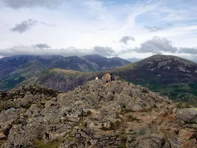
Summit ridge of Haystacks
The summit of Haystacks consists of a short rocky ridge raised slightly above the plateau. The picture was taken from the cairn though both ends are of roughly equal height.


Haystacks summit cairn with Great Gable
From my lunch stop on the top, Green Gable, Great Gable and Kirk Fell across the top of Ennerdale


Considering the relative height of this peak in relation to its neighbors, the summit views are impressive to say the least. Great Gable and Pillar along with the wild upper reaches of Ennerdale impress the most while High Crag at the end of the High Stile Ridge appears of vast proportions across Scarth Gap. Despite the picnicking families I secured a comfortable rock just below the cairn which was a great spot for lunch.

Ascent 500m/1640ft  >>> Descent 500m/1640ft >>> How far? 10.4km/6.5 miles
Distance is from Buttermere Youth Hostel

Pete Buckley October 2013

Thursday, 20 June 2013

Walking in the Lake District - a Return to Scafell Pike


One Spring day thirty something years ago, two boys set out with their fathers to climb England's highest mountain. Myself, Dad, Cousin Brian and Uncle Gordon headed up the Sty Head track from Wasdale before following the trail passing beside Sprinkling Tarn beneath the gaunt and sombre crags of Great End. All were going well and the intrepid party were confident of success when as happens all too often in the
Lakes; the weather had the last say.

So it was that at our high point of just under 2400 feet by the shelter below Esk Hause, in rapidly deteriorating conditions, the decision was made to abandon the quest and bring to a close my first real experience of fellwalking.

Much more recently on an October morning when cloud hung about the high summits, just two of the original party set off once again from Wasdale to complete the route we had started years earlier. This time I acted as guide having climbed the Pike many times while Brian made the trip in memory of his dad - my Uncle Gordon - who sadly is no longer with us.

 
Great Gable from Wasdale Head
The weather was still fairly clear as we set off on the Sty Head path from Wasdale below the peak of Great Gable


Styhead Tarn
As we reached the top of the pass Styhead Tarn comes into view. the path down that side goes to Seathwaite in Borrowdale though our route lay up to the right


Between Styhead and Esk Hause
Brian on the path above Styhead Pass as we approached Sprinkling Tarn.This trail goes to Langdale... eventually.  Great Gable is the mountain behind.


Sprinkling Tarn
At almost 2000 feet Sprinkling Tarn is the higher of the two tarns on this route. It has the dubious honor of being the wettest place in England


Scafell Pike path
The upper part of the route to Scafell Pike leads across a rough and  stony landscape between the 3000 foot high subsidiary summits of Ill Crag and Broad Crag


The summit of Scafell Pike
At last the top! Looking out over Morecambe Bay from the highest mountain in England


And so we had climbed the mountain by the route we had set out on the first time around - the easiest way though not the shortest - by Esk Hause. Our return was by the Corridor Route which is a fine path and links Styhead Pass with Lingmell Col below and to the North of the summit.The paths are easy but rough in places and we were surprised at the number of people still going up at this late hour and as it turned out, our  own adventure was not yet over. 

Descending the corridor route just beyond the deep chasm of Piers Ghyll. we became aware of people clearly in some distress. They turned out to be a father and son team who on attempting to descend the slopes down to the Left had got into difficulty. They were able luckily  to rejoin us when they spotted where we were on the right path.

For those who know this route we were just below the short rocky step that you scramble down when climbing from Sty Head and the way was not so obvious in descent where the step has to be climbed. It was marked with a cairn but in the fading light and worsening weather (that's why there's no more photos) the two had missed it. The step could appear daunting from below but there is an easy path ten or fifteen feet above!

Brian led the way and I followed the man and boy - who was a similar age to the two boys at the start of this story - up the rocks to the easy path above where they were back on safe ground. At least our return to Scafell Pike had done some good. This route is a safe corridor through a maze of crags and deep gullies so it is always best to stick to the main path unless you know it really well!

Pete Buckley June 2013

Start and finish at The Green, Wasdale Head  >>> How Far? 14.5km/9 miles >>> Total Ascent? 3200ft/975m >>> Highpoint Scafell Pike 3210ft/978m


.