Pages

Thursday 20 June 2013

Walking in the Lake District - a Return to Scafell Pike


One Spring day thirty something years ago, two boys set out with their fathers to climb England's highest mountain. Myself, Dad, Cousin Brian and Uncle Gordon headed up the Sty Head track from Wasdale before following the trail passing beside Sprinkling Tarn beneath the gaunt and sombre crags of Great End. All were going well and the intrepid party were confident of success when as happens all too often in the
Lakes; the weather had the last say.

So it was that at our high point of just under 2400 feet by the shelter below Esk Hause, in rapidly deteriorating conditions, the decision was made to abandon the quest and bring to a close my first real experience of fellwalking.

Much more recently on an October morning when cloud hung about the high summits, just two of the original party set off once again from Wasdale to complete the route we had started years earlier. This time I acted as guide having climbed the Pike many times while Brian made the trip in memory of his dad - my Uncle Gordon - who sadly is no longer with us.

 
Great Gable from Wasdale Head
The weather was still fairly clear as we set off on the Sty Head path from Wasdale below the peak of Great Gable


Styhead Tarn
As we reached the top of the pass Styhead Tarn comes into view. the path down that side goes to Seathwaite in Borrowdale though our route lay up to the right


Between Styhead and Esk Hause
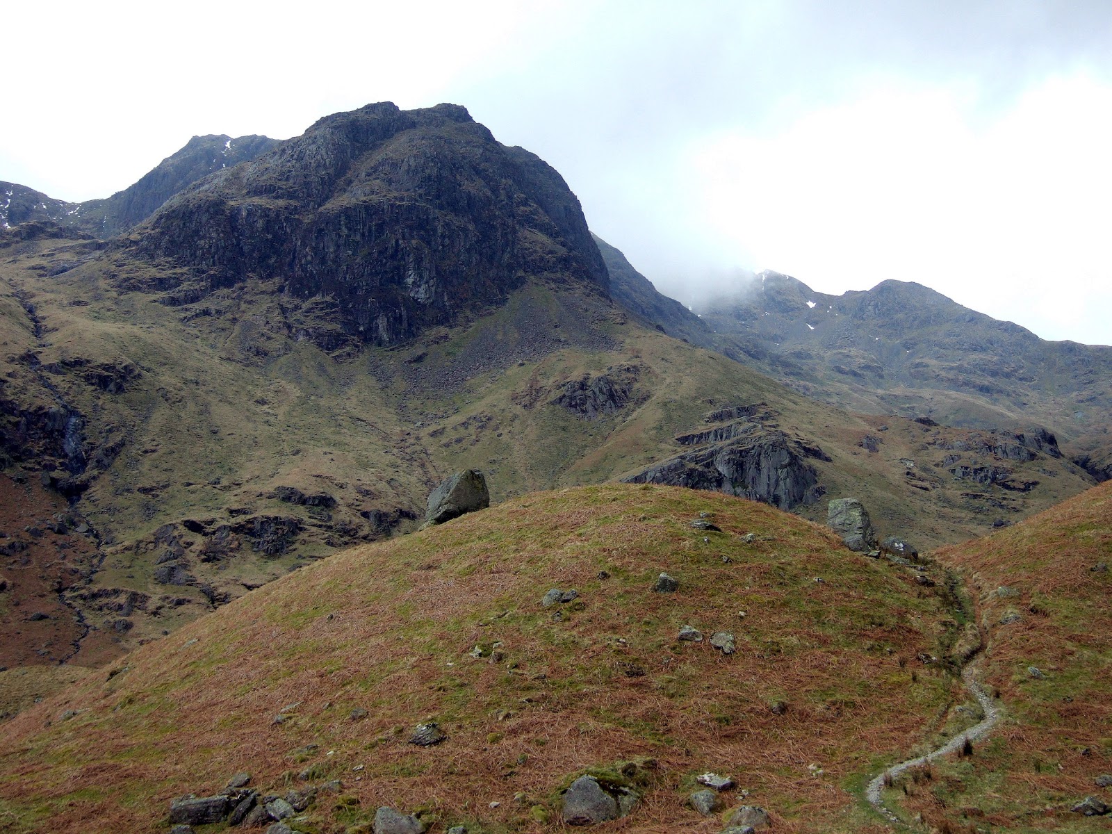
Brian on the path above Styhead Pass as we approached Sprinkling Tarn.This trail goes to Langdale... eventually.  Great Gable is the mountain behind.


Sprinkling Tarn
At almost 2000 feet Sprinkling Tarn is the higher of the two tarns on this route. It has the dubious honor of being the wettest place in England


Scafell Pike path
The upper part of the route to Scafell Pike leads across a rough and  stony landscape between the 3000 foot high subsidiary summits of Ill Crag and Broad Crag


The summit of Scafell Pike
At last the top! Looking out over Morecambe Bay from the highest mountain in England


And so we had climbed the mountain by the route we had set out on the first time around - the easiest way though not the shortest - by Esk Hause. Our return was by the Corridor Route which is a fine path and links Styhead Pass with Lingmell Col below and to the North of the summit.The paths are easy but rough in places and we were surprised at the number of people still going up at this late hour and as it turned out, our  own adventure was not yet over. 

Descending the corridor route just beyond the deep chasm of Piers Ghyll. we became aware of people clearly in some distress. They turned out to be a father and son team who on attempting to descend the slopes down to the Left had got into difficulty. They were able luckily  to rejoin us when they spotted where we were on the right path.

For those who know this route we were just below the short rocky step that you scramble down when climbing from Sty Head and the way was not so obvious in descent where the step has to be climbed. It was marked with a cairn but in the fading light and worsening weather (that's why there's no more photos) the two had missed it. The step could appear daunting from below but there is an easy path ten or fifteen feet above!

Brian led the way and I followed the man and boy - who was a similar age to the two boys at the start of this story - up the rocks to the easy path above where they were back on safe ground. At least our return to Scafell Pike had done some good. This route is a safe corridor through a maze of crags and deep gullies so it is always best to stick to the main path unless you know it really well!

Pete Buckley June 2013

Start and finish at The Green, Wasdale Head  >>> How Far? 14.5km/9 miles >>> Total Ascent? 3200ft/975m >>> Highpoint Scafell Pike 3210ft/978m


.


Tuesday 18 October 2011

Blencathra Without the Crowds

Blencathra walkThe Glenderamackin Valley is frequented by many times more sheep than walkers yet it provides not only a varied and interesting way into the heart of the Caldbeck Fells but also a quiet and equally varied route to the summit of Blencathra. Having been thwarted a couple of weeks before by weather that suggested building an ark might be a good idea, I set out again on a morning when yes - it was raining once again.

A wide path leaves Mungrisdale in a westerly direction then a south westerly one following the fast flowing River Glenderamackin whose level was noticeably lower than last time. My route followed the river - ignoring the more obvious paths branching right up the hillside - and after a small footbridge enters the river valley proper. It's good remote country this and you won't see many people. Steep green hills rise from the stony bed of the beck and today mist crowned their tops though the rain was at last easing off.

Glenderamackin Lakeland
The path crosses a river descending from the right after about a mile - this had required thought last time to stay dry - but today was just a case of walking across on stepping stones. Another path left to climb the fells on the right, this one going to Bannerdale Crags up the interesting East Ridge - next time - but I kept on following the Glenderamackin towards its source.

The course of the valley turned back around to the right as the path climbed steadily and the popular path to Blencathra from Scales appeared on its opposite side occupied by several parties marching towards their objective. By crossing a wooden bridge just below, this path can be joined if so desired. If the weather is as bad as it was the last time I was here and the aim is a shorter walk then climbing to the ridge opposite and turning left will take you back along Souther Fell which is a fine route and leads back to Mungrisedale as a ridge walk to contrast with the valley trek to this point.

Blencathra view looking eastNow heading more to the North West, the path continues up towards the jagged outline of Foule Crag and Sharp Edge into wilder terrain to emerge after a short climb at the Glenderamackin Col and the wide open spaces of the Caldbeck Fells. Turning left, a steeper ascent up a windblown ridge brought me easily up to the interesting peak of Foule Crag just as an icy wind blew away the mists to gradually reveal the spectacular far reaching views Blencathra is known for. A short walk across a cold grassy col brought me to the fell's highest summit known as Halls Fell Top (868m/2847ft) where the mountain's fascinating ridge network was laid out below.

Derwentwater from BlencathraReturn was by the same route though in the interests of peak bagging - I am finishing off the Wainwrights List - I diverted to the fell known to those who have heard of it at all as Mungrisdale Common. The name does not inspire an ascent and if Wainwright had not included it in his guidebooks then no-one would ever go there but the faint path over the breezy tussock country was a pleasant walk - if a little damp in places - and was worth the detour. In fact on a summers' day when the crowds and all their dogs are trooping up Blencathra this lonely corner of the Caldbeck Fells would be a good place to have one's lunch. If you're tempted, head north from the vicinity of a stone shelter by a small subsidiary peak between Foule Crag and Glenderamackin Col.

A curious thing about the "ascent" of Mungrisdale Common - altitude 633m/2077ft - is that while with most hills or mountains you walk or climb up to the top, here you walk down to the cairn! It's about a mile each way.

From the col you can easily visit Bowscale Fell and Bannerdale Crags - two other Wainwrights - returning by one of the paths we passed earlier to Mungrisdale but today time was getting on so I didn't. The walk in total is 15km or just over 9 miles return to Blencathra or with my diversion today it's 11 miles exactly.

Pete Buckley October 2011

Carrock Fell and Bowscale Fell


Blencathra from Mungrisdale Common

Blencathra from Glenderamackin

Narrow Edge on Blencathra

The view down from the summit is of the ridge known as Narrow Edge - here's an account of the ascent - it's easier than it looks!

Friday 7 October 2011

The Empty Hills - A Walk from Birker Fell to Green Crag

The Duddon EstuaryIn the south western corner of the Lake District between Eskdale and the valley of the Duddon there lies a relatively unvisited part of the National Park. It is a remote region of rough tussock country, gnarled crags and scattered tarns and when the mist is down on the fells - which it frequently is - feels as far from civilisation as anywhere in the world.

You won't see many walkers here - in fact on this hike to Green Crag I saw nobody at all - and if Wainwright had not listed this fell in his classic guidebooks to Lakeland then it is doubtful anyone would ever ascend it. That's a shame because despite its lowly altitude of 1602 feet, it is a fine rocky summit with some wonderful views across a landscape that is little touched by our destructive activities.

My route began from the Birker Fell Road which links Ulpha in the Duddon Valley with Eskdale. The best place to leave the road is just past the cattle grid that leads to open fellside (direction Eskdale) and the line to take is to initially follow the wall that runs uphill approximately in a north easterly direction. There is a faint path that fades in and out of existence but the aim is to keep to the higher ground which is less boggy than lower down. I say less boggy meaning that it is still boggy but not so mush as  a direct route would be.

from Great Worm CragWhere the wall goes its separate way to the right we keep to the highest ground on a wide grassy ridge. Again the path is sometimes in evidence - sometimes not - and was probably made by sheep in any case. The first summit reached is Great Worm Crag which today I bypassed on the right having been before, where Green Crag comes into view ahead seen in the picture on the right.

It looks a long way off but is actually less than 1 mile though anyone making a beeline for it across easy looking grassy slopes will get wet. Drier ground is found by first heading approximately ENE to White How then north to Green Crag. The dampness is easily forgotten with the views back to the Duddon Estuary and into the lonely country ahead where Scafell and Scafell Pike rise beyond Green Crag's rocky looking peaks.

Duddon Estuary from White HowFrom White How a pleasant grassy promenade takes the few walkers who come here around the back of green Crag to where a path climbs to the left finishing with an easy little scramble to finish at the summit. Arriving here is almost unexpected as it looked a lot further from Great Worm Crag and there is time to relax and enjoy the views of the Scafell Range to the North which today I had to myself.

The walk from the road is 2.5 miles so it's about five miles return - a good way to spend an afternoon.

Pete Buckley August 2011


Scafell and Scafell Pike from Green Crag

Tuesday 20 September 2011

Fairfield by Deepdale and Cofa Pike

The best known and most popular walking route on Fairfield is almost certainly the Fairfield Horseshoe from Ambleside or Rydal but while this is undoubtedly a great day out, it doesn't venture onto the mountain's unseen northern face - it's finest asset.

Here dark and forbidding crags stand guard over the lonely fastnesses of Deepdale and shattered screes replace the sheep cropped turf of the Ambleside slopes. This is a place that has changed little in a thousand years - the home of the raven and the buzzard. It is places like these that keep us coming back.

This walk begins at Bridgend between Patterdale and Brothers Water and covers 14km with some rough steep sections around the head of Deepdale and Cofa Pike. On a weekend when the car park near Brothers water was almost full I saw only one other walker for the length of Deepdale which shows it is not frequented by the crowds.

Leaving the car park I walked north along the road as far as Bridgend where I turned left down a lane marked with a footpath sign. Where this bends right you turn left again through a gate before the row of houses to follow a track firstly past Deepdale Hall Farm then - some distance on - Wall End. Here the path crossed a stream and headed into the unpopulated valley ahead.


Fairfield from Deepdale
As the path rounded an intervening slope the rugged northern side of Fairfield comes into view ahead. Deepdale Hause is the col on the right with Cofa Pike above. The summit was still in cloud.
 
The path follows the right bank (when ascending) of the river through a level marshy area before beginning a steeper ascent through a region that looks like a geography lesson about the Ice Age; both U-shaped and hanging valleys, moraines, boulders (known as erratics) left by retreating ice - Deepdale has it all but we don't have to try and remember how these things got here - just enjoy the view!

Lakeland valley

Geography field trip over, the route ascends steeply to one of those so called hanging valleys - a lonely
dale high above the lower one enclosed by the crags of Fairfield with the steep slopes of St Sunday Crag
rising to the right. The way out of here becomes apparent as we reach its head along a rough path.

The path fades as it begins to climb again where there are a choice of ways to gain the ridge above. The obvious gully on the left leading up just to the right of Cofa Pike looks steep - probably because it is - and my route lay further to the right nearer the col linking to St Sunday Crag where there were vestiges of a path and the crags could be avoided. I don't think Deepdale Hause has been used as a pass for many years and finding the way up to it would be dangerous in mist.

The last part up to the ridge is the steepest part of the route and a shelving path is met leading to the ridge itself without difficulty. Cofa Pike looks daunting from here but it's a fun walk up a path. The scrambles are on the crest and can be avoided if so desired.


Hevellyn from Deepdale Hause


The ridge gained we meet the broad path from St Sunday Crag - that's my favorate route up Fairfield - and are greeted with this view of Dollywaggon Pike, Nethermost Pike and Helvellyn across Grisedale. We turn left at this point but if you didn't know that then you need to think about getting the map out!

The path ascends steeply over Cofa Pike - follow the crest at the top if you like scrambling - and on up to Fairfield's flat summit at 2863 feet or 873m - the route's high point.

The next photo shows the view from just past the summit of Fairfield, looking towards the start point near Brothers Water, itself hidden behind the intervening ridge which is known as Hartsop Above How. This ridge also offers a fine route down to finish at the road half a mile beyond the start point.

View east from Fairfield
To descend this way follow the path roughly ENE down from the next summit of Hart Crag. Note: The start of this way down descends between crags and is easy as long as the path is not lost so the advice of many good stories - do not leave the path - holds true here! Dangerous in mist - do not try! The descent along Hartsop above How is easy and enjoyable all the way down with stunning views of Dovedale. This way is probably better than the one I did today but I had already done it previously.

For today's route follow the path up and over Hart Crag which rises ahead. There is a wide and usually popular path following the Fairfield Horseshoe - and descend the rough slopes on the far side to a grassy plateau between Hart Crag and Dove Crag. Near the low point between the 2 fells saunter off to the left towards where a prominent cairn is seen in the distance. People will doubtless think you are going the wrong way but beyond the cairn a faint path is found which becomes more pronounced lower down.

Lakeland valley of Dovedale

The start of this path is not obvious but it is there and it leads to a hidden grassy hollow containing a large boulder which is a wonderful and quiet spot to stop for a while - if the sun is out that is - and the view of Dovedale from its eastern edge is sublime.
The hollow lies above steep ground and the path heads down a gully below the rock wall of Dove Crag on the right. Stone steps have been placed to facilitate progress as this route used to be excessively loose and rough. The following picture shows the view down the gully twards the wild upper part of Dovedale. Once down the steep section a choice of ways is found - to cross the river or not?

The route down to Dovedale

Both lead to the farm of Hartsop Hall and on to Brothers Water but the left hand path is more direct following the slope down while the other - across the river - descends into woodland and through Dovedale itself. Both are okay but I guess if time is no issue the valley one is more interesting - if you're in a hurry keep left. The valley path initially fords the stream but if this looks dodgy as after heavy rain which is frequent here then there is a footbridge a little further on.

Pete Buckley May 2011

Monday 14 March 2011

The Eastern Edge of Lakeland - a Circuit of Longsleddale

Longsleddale
Along the eastern boundaries of Lakeland between the high fells and the Shap road there lies a remote hill country that sees few visitors compared to the better known areas to the West. Only peak baggers and walkers who like solitude would recognise the names of Tarn Crag, Harrop Pike and Grey Crag but while the region may lack the spectacular scenery of Wasdale Head and the Buttermere valley, it does have a charm of its own.

The only road to venture up here is the 5 mile single track lane to Sadgill at the head of Longsleddale; itself reached from the A6 just north of Kendal and it is from Sadgill that this walk starts and finishes. For the Wainwright bagger the tally is 5 - the first 2 of which I had not previously done myself - and the walk is effectively a horseshoe around the head of Longsleddale lasting ten and a half miles that sets off through the lonely country to the East of the valley and finishes on the more familiar ridge of Harter Fell and Kentmere Pike to the West.

The parking area is at the road end just before the bridge - I don't know of a bus up here - and the route begins through the gate on its eastern side. Please take care not to block the gates or track as space is limited especially at weekends. There is no clear path on the other side of the wall but make for the gap in the wall that is visible above and to the left.

Beyond the second wall a faint path climbed the steep fellside ahead skirting around to the right of the rocky outcrop above and ascending a shallow gully. At the top of this the gradient eased and there was soon a third wall across my path but with no gap. Here I followed the path to the right alongside the stone wall until an opportunity arose for climbing it - which I duly did. I needn't have done so because a little further on a stile crosses it in any case.

From the stile a path leads up the hill on the far side of the wall - where it is unclear keep left towards the highest ground which is known as Great How. From here an obvious track makes its way across the undulating terrain ahead. The first summit - Grey Crag - is ahead and slightly to the right and the path does make its way in this direction in front of the peak before turning back left to the summit. This avoids some steep rough ground that a beeline would cross.
The summit of Grey Crag - the easternmost of the Wainwrights - is an isolated spot as one could find in the Lake District and I was not surprised to have it to myself. Even the sheep were elsewhere. Mist hid the fells to the West and the most eye catching view was that of the Howgills to the South East.

The way to Tarn Crag is a case of following the faint path from here towards where a fence is seen on the far side of the summit. A distant stone pillar was visible to the east across a 2000 foot high plateau of tussock country that seemed to mark the true edge of the high country so I diverted towards it. The cairn is on nearby Harrop Pike about half a mile diversion eastwards from the fence and it provides extensive views over the Shap Fells and the Pennines. If you were trekking cross country to the Shap Road (A6) this is the way you would come.

A note for peak baggers; Harrop Pike is not a Wainwright but is a two thousander just in case the decision to visit it rests with such things, but it's an easy walk that adds less than a mile to the route today and on a warm sunny day it would make a great lunch stop.

Returning to the fence it was just a case of following the path north down into a marshy gap then back up a gradual climb to Tarn Crag where there was no view. A stone tower adorns this fell too - just to the west of the highest point but it's a much more substantial construction than the cairn on Harrop Pike.

There are crags to the West of Tarn Crag's summit so to access the Gatescarth Pass track we must head north again. In the end because of the visibility I followed the clear path all the way to the col with Branstree instead of looking for the short cut down along a stream. There was no path that way in any case. I soon picked up the track from Mosedale and followed it down to the bridleway.

When the Gatescarth route is met we turn right and follow the wide track steeply up to the top of the pass where - just after a gate - another obvious path branches left to ascend Harter Fell. Carrying on will take you down to Mardale and Haweswater.

I followed the wide route up towards Harter Fell. There had been a metre of snow the last time I was up here which is probably why I didn't remember the path being like this. I followed it to the top where - yes there was no view again. That's a shame because the view of Haweswater from Harter Fell is just superb - the best place is an area of rocks to the right of the path just before the first summit is reached. The true summit is almost another half a mile after this. There was no view there either.

Now I was on the way back - and it was nearly all downhill from here. An obvious path leads south then south east to make the small climb to Kentmere Pike before continuing down the gentle slope to Shipman Knotts. The higher ground to the left of the path between these 2 fells is the top of Goat Scar and is well worth a visit - in better visibility - for the views of Longsleddale.

After Shipman Knotts the terrain changes again and the descent becomes steeper and rockier than the route so far. The path descends beside a wall then crosses a marshy plateau before making a steep descent towards the Sadgill-Kentmere bridleway. It isn't quite a scramble but as close as this route gets. When the bridleway is reached we turn left back to Sadgill which is not far - less than a mile downhill.

Pete Buckley Mar 2011

Summits: Grey Crag 638m >>> Harrop Pike 637m >>> Tarn Crag 664m >>> Harter Fell 778m >>> Kentmere Pike 730m >>> Shipman Knotts 587m

Essentials >>> Up 950m >>> down 950m >>> How Far? 17km >>> Start and finish at Sadgill Longsleddale >>> more walks and hikes

Wednesday 16 February 2011

A Walk in the Rain - 2 Wainwrights from Newlands

Newlands Hause
The long days of summer when the trail stretches away ahead until the golden evening dresses the hills in patterns of light and shade and the westering sun lights the path homewards are the truly memorable ones. They shine like a beacon in our minds through the dark of winter and bring us back to the hills time and time again as if we are searching for some half remembered place in a dream.

Today at Newlands Hause though was not one of them. Driven before a westerly gale, the rain drifted in watery veils across the open fellsides and a grey nimbostratus hid the higher summits from view. This is perhaps the more usual scene to greet those who come to walk in the Lake District but at least the Ard Cragsfells looked dramatic and Moss Force just above the pass was at its best. But yes - these are excuses - the weather was grim and if I did the walk I would get wet.

Part of the joy of doing the Wainwrights - the fells classified by the late AW Wainwright in his guides to Lakeland - is that some of them can be ascended so quickly and easily that on days like this the getting wet part is not for long enough to become too tiresome. Indeed Latrigg took me and Josh rather less than 10 minutes from the Skiddaw car park and the view from there far outweighs that tiny effort. These two fells I was climbing today - Ard Crags and Knott Rigg - involved slightly under 4 miles of walking and just 1050 feet of ascent for the return trip.

From the small parking area at the top of Newlands Hause set off along the path on the opposite side of the road to the spectacular waterfall of Moss Force - after visiting it 5 minutes the other way - which is actually signposted to Ard Crags if the sign has not since blown away. The path follows the obvious line up a fairly steep grassy ridge ahead past a small rocky outcrop where there was some shelter if only because the wind was blowing the rain over the top of it. After here the steepness eased and the ridge led up past another outcrop to the small cairn atop the grassy ridge of Knott Rigg.

Leaving Knott Rigg the way descends only slightly to cross a wide grassy area which was not overly boggy even in this weather to ascend the steeper slope to Ard Crags itself one mile distant.

Today I saw no-one else on this route and I was in all probability the only one to visit these 2 summits and unlike those who no doubt climbed nearby Crag Hill (aka Eel Crag) or Grasmoor I had a view to enjoy as I remained below the cloud level for the duration of the walk. These lower peaks in the Lake District are often - quite wrongly - neglected in favour of their more illustrious neighbors but they usually offer fine summits and enjoyable quiet approaches whether the sun shines or not.
Pete Buckley Feb 2011
summits Knott Rigg 556m (1824ft) >>> Ard Crags 581m (1906ft)

Essentials >>> Up 320m >>> Down 320m >>> How Far? 6.4km return >>> Start and finish at Newlands Hause (minor road between Buttermere and Braithwaite) >>> More walks and hikescan be found on my website

Friday 19 November 2010

Causey Pike and the Sail Pass

newlands
The familiar outline of Causey Pike is prominent in the western panorama from Keswick and Derwentwater and the popular climb to its summit is a fine route whether done on its own or as part of the ridge route terminating at Eel Crag (Crag Hill on OS maps). This route is a circular outing that goes as far as Sail (just beyond the Sail Pass) and returns over the lesser but no less interesting peaks of Outerside and Barrow. It could be extended to Crag Hill - which was considered - though more retracing of steps would be involved and the weather did not encourage a longer trip today.

Leaving the car at an ample roadside space on the Newlands Road just over a mile south of Braithwaite I set off south along the road towards the precipitous looking slopes of Rowling End - the eastern spur of Causey Pike - which was my first objective. The path on the right is our return route and is not a short cut to Causey Pike. There is another free parking place just along the road here so please do not abandon vehicles in the passing places - you will not be thanked for it!

As soon as I had crossed the beck by a small bridge, a path led off up the steep slopes to my right. It was a relief to start the climb as it was not a warm day - only 4 degrees C at valley level and breezy with it. The path led easily at first up the valley with the beck down on the right and Causey Pike rising steeply to the clouds ahead. The main path carries on climbing across the slope but after a short while I took a steeper path that ascended through the heather to the left. The main route is okay but this path ascends to the top of the spur of Rowling End and provides superior views up the Newlands Valley once the top is gained.

This way was steep though and hands were needed in a few places as easy rock passages were encountered. It was more that the rock was slippery than difficuly but the views were worth the extra effort and I soon found myself on a wide heathery ridge top with the wild scene of the head of the Newlands valley bounded by High Spy and Dale Head, contrasting with the wooded shores of Derwentwater beyond the fields and farmhouses of the dale below.

Ahead was the steep cone of Causey Pike , mist clinging to the summit crags. It reminded me from here, of a smaller and tamer version of the Matterhorn with the rocky bulge just below the summit. I passed the point where the main path reaches the ridge - Sleet Hause - and started up the ridge.

A good path led without difficulty up the ridge and I gained height quickly soon finding myself below the rocky section. The path heads more or less straight up this rocky dome and while the hands are certainly needed, the way up is much easier than it appears from below then - just as the steepness eases - you are on one of the finest summits in the region. The highest point is the top of the steep rocky bulge seen from below though as the rocks are surmounted one reaches a small grassy platform.

It was a shame that I had reached the cloud layer as the view - which had improved with height would have been excellent from this eagle's nest of a vantage point. The top of Causey Pike is made up of several - 5 I think - bumps which are visible in views of the fell from below. The path now led sucessively over these. The first one appears to be the highest but there's not much between it and the third one. There was no mistake about the route now - on along the ridge through a chill windblown fog towards the next peak - Scar Crags - itself invisible about a kilometre ahead.

The ridge widened for a while and a constructed raised pathway traversed some damp looking areas before a steady ascent brought me to the top of Scar Crags where the view matched that from Causey Pike exactly - a circle of turf and stones beyond which existed only a cold rushing blankness.

The path led on down the far side into the mist and I was soon at Sail Pass where this trail crosses the one linking Braithwaite and Buttermere. The logical circular route here branches right on the Sail Pass towards Braithwaite but with a nod in the direction of peak bagging I decided to ascend Sail before heading down that way. The summit is not much further and was one of the Wainwrights I hadn't climbed before. I had originally planned to go as far as Eel Crag aka Crag Hill but I had been there not so long ago in better weather than this and it would mean retracing my steps if I wanted to visit Outerside. Besides my planned descent of Crag Hill by the Shelf Route - also a fine route of ascent - from Coledale requires clear weather.

Heading up the easy slope to Sail on the wide path, the landscape subtly changed. Sprigs of heather and longer strands of grass beside the path became tinged with white hoar frost and the small patches of snow ceased to be soft. At 2400 feet I had reached the freezing level or 0 degree isotherm. Thanks to the mist I had also entered what aircraft pilots call icing conditions where cloud droplets freeze on contact with solid objects in this case clothing which is far less of a problem than the control surfaces of an aircraft. The forecast snow had not arrived though.

The top of Sail was a cheerless place in this weather and I set off back down to the pass where I emerged below the mist to the wild scene of upper Coledale with the ruined mine below the waterfall at its head. The cloud hid the surrounding summits from view and their rough slopes dropped from the mist. I was passed by 2 girls who had been on Sail and were also heading for Outerside which was the interesting looking cone shaped hill in front that was currently free from mist.

After I had eaten most of my lunch I set off down the track on the Coledale side in a roughly north easterly direction. This is an interesting path across the rough slopes of Scar Crags high above the valley and it led to more level ground where I branched off left towards Outerside. This was grassy terrain and became quite boggy for a while before I found solid ground that led easily up to the fine stony summit of Outerside. These smaller fells are often unjustly neglected yet they can be just as enjoyable to climb as the major fells. The 2 girls had headed up here but no-one else had. They must be doing the Wainwrights as well!

I walked down the ridge towards the expansive views of Keswick, Derwentwater and the lower slopes of Skiddaw and passed the 2 girls again - they must have thought I was following them! The ridge steepened down to a damp heathery plateau interlaced with many small paths. I kept to the right of Stile End - the hill ahead - and found a path that descended to the right where I arrived at the col between this and the next hill known simply as Barrow. The route over Outerside is longer but much more of a joy than the main path in the valley below. I would rejoin it lower down after conquering Barrow.

A clear path led onwards along the ridge and 10 minutes or so brought me to the top of Barrow - only 455m or 1493 feet but commanding a wonderful view of the vale of the Derwent as well as Newlands directly below in the fading light of late afternoon. There's no safe route straight down so to get down there I retraced my steps towards the col I had just left. Here I met the 2 girls again and they were doing the Wainwrights - why else would anyone be up here at this hour? They'd had a good day out but were now faced with a drive back to London - I did not envy them! They had been the only people I had seen since my descent to Sail Pass.

From the col I cut straight down the fellside where a small path joinrd up with the main one below on which I turned left down the valley. This path rounded the corner in the valley and followed the road along to where I was parked. I saw no-one along here either.

Pete Buckley November 2010

Summits >>> Causey Pike 637m/2090ft >>> Scar Crags 672m/2205ft >>> Sail 773m/2536ft >>> Outerside 568m/1864ft >>> Barrow 455m/1493ft

Essentials >>> Up 970m >>> Down 970m >>> How Far? 12km >>> Start and finish at the Newlands Road near Stair >>>